Right now, in the middle of July, one of the Upper Peninsula’s most photographed winter attractions does not exist.
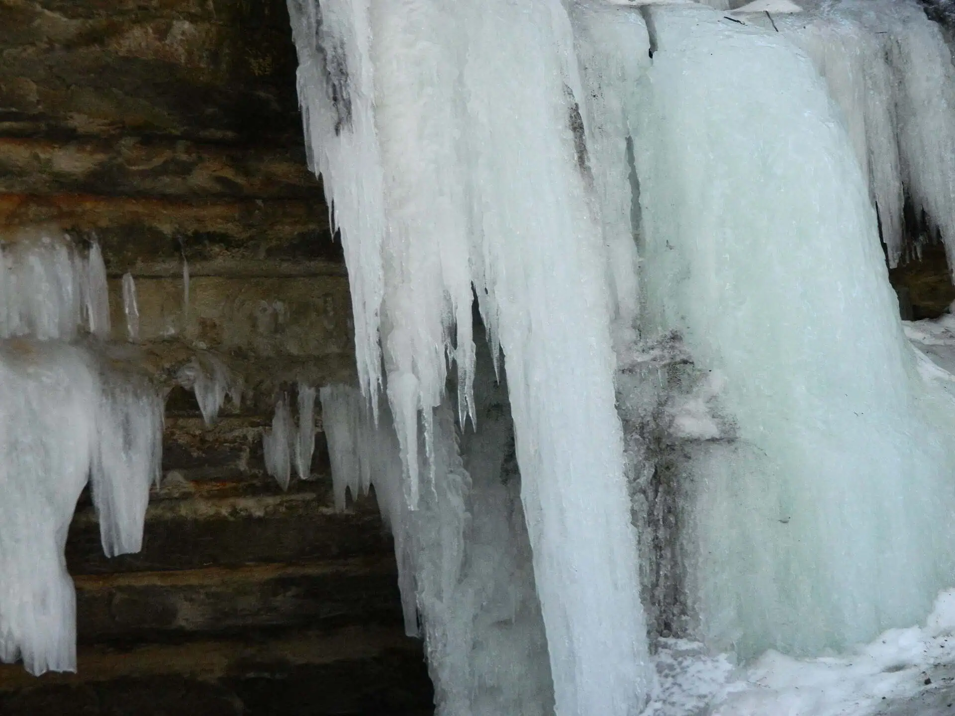
Go stand where the Eben Ice Caves are and you will find a sandstone cliff in the woods. No waterfall. No cave. Nothing worth the drive. The whole thing has to be built again from scratch every winter, out of water and cold, and it takes months.
They are not caves, and there is no river
The official name is the Rock River Canyon Ice Caves. Everyone calls them the Eben Ice Caves, after Eben Junction, the small crossroads at M-94 and Eben Road in Alger County, about twenty miles southwest of Munising.
They are not caves in any geological sense. Rock River Canyon is roughly 150 feet deep and lined with sandstone outcrops that erosion has undercut into concave overhangs. Through the year, groundwater and snowmelt seep down through that porous rock and spill over the lip of the overhang. In winter, that slow seep freezes where it falls — layer on layer, week after week — until a curtain of ice hangs down across the entire front of the outcrop and seals it off.
The cave is the gap left behind: the dry hollow between the rock face and the wall of ice now standing in front of it. Walk around the edge of the curtain and you are inside, in a room lit entirely by daylight coming through several feet of translucent ice, with the sandstone at your back.
The curtains average around 30 feet tall. The ice can run more than three feet thick, solid enough that people climb it. And it is not white — the sandstone and the cedars leach into the meltwater and turn the whole thing a strange amber gold.
The trail that is not a trail
Here is the part that surprises people who have been going for years: the Eben Ice Caves have no official trail.
The Forest Service is straightforward about it. There is no designated National Forest System trail to the ice caves. What exists is a route that visitors pack down themselves in the snow each winter, which becomes obvious and well established simply because so many people walk it. The only authorized trail anywhere in the Rock River Canyon Wilderness is Rock River Falls Trail, at the opposite end.
And the field you cross to get there — that windswept quarter mile of open ground everyone remembers for the wind chill — is private property. The landowner permits winter access. That is the arrangement. One of the best-known natural attractions in the U.P. runs on a packed-snow footpath and the goodwill of a neighbor.
That has consequences. The unofficial route crosses unmapped drainages feeding Silver Creek, and the Forest Service has flagged high erosion potential in the riparian zone. The canyon’s groundwater-fed system is genuinely cold water — refuge habitat for native brook trout, which the agency treats as an indicator species for the whole area. Crowds and a route nobody engineered are a bad combination for that.
So the Hiawatha National Forest has opened a project to establish formal access, a designated trail running to the ice caves from both public and private access points. It is working its way through the process now. A separate proposal to reroute the North Country Trail through the wilderness has been sitting on hold since 2022.
If you go
January and February are the reliable months, because the caves need sustained cold to build. They usually hold through March and start coming apart in April. Visiting is free.
Everything else is on you. There is no maintained path, no railing, no ranger at the trailhead. Ice that took two months to form comes down without notice in a thaw, and standing under a collapsing curtain is exactly as bad as it sounds — the same lesson the cliffs at Pictured Rocks keep teaching about sandstone and freeze-thaw, just on a schedule of weeks instead of centuries.
Which is the real appeal, once you think about it. Most landmarks are things that have been standing a long time and will keep standing after you leave. This one is assembled and destroyed every single year. The version that goes up next January will be the first time that particular arrangement of ice has ever existed, and by May it will be gone without a trace — back to a plain sandstone cliff in the woods, waiting for the kind of winter the U.P. is unusually good at supplying.
More worth reading


Sources, credits, and reporting details
Sources & accountability
How this story was reported
Editorial methodArchival synthesis
Last verifiedJul. 23, 2026
Corrections statusNo material correction note is recorded on this article.
AI assistanceResearched and drafted with AI tools. Reviewed and approved by editor Keegan O’Brien.
Verification note: Initial ledger, verified 2026-07-23 during publication prep. Formation mechanism, dimensions, seasonality, the absence of an official Forest Service trail, the private-property field access, the resource concerns in the Silver Creek riparian zone and the pending trail project were checked against two primary Forest Service sources plus corroborating coverage. The trail project is described as in process, not decided, because the agency record shows no decision. The article does not publish precise parking directions beyond the road references already widely published, given the private-land access and erosion concerns. No direct quotations. Featured image CC BY-SA 4.0, credit ThePenultimateOne, resized without cropping. No AI-generated or AI-assisted media.
Primary sources
-
Sustainable Recreation Strategy: Rock River Canyon Wilderness, Eben Ice Caves — USDA Forest Service, Hiawatha National Forest
Featured image record. Published Jun. 2, 2026. Accessed Jul. 23, 2026. Federal public information; cited.
Primary federal source; basis for the no-official-trail and resource-impact sections.
-
NEPA Project 0910: Eben Ice Caves Trail (Rock River Canyon Wilderness Area) — USDA Forest Service, Hiawatha National Forest, Munising Ranger District
Featured image record. Published May. 18, 2026. Accessed Jul. 23, 2026. Federal public information; cited.
Current agency project record; the article describes it as in process rather than decided.
Additional reporting
-
Exploring Eben Ice Caves (aka Rock River) Are a Winter Must — Awesome Mitten
Featured image record. Published Jan. 30, 2026. Accessed Jul. 23, 2026. Copyright Awesome Mitten; cited.
Source of the 30-foot average and the amber colouring.
-
Eben Ice Caves Michigan: Everything You Need to Know Before You Go — The Perna Team
Featured image record. Accessed Jul. 23, 2026. Copyright The Perna Team; cited.
Real-estate marketing blog; used only for widely corroborated geographic and formation details.
-
Rock River Canyon Wilderness — Black Coffee at Sunrise
Featured image record. Accessed Jul. 23, 2026. Copyright Black Coffee at Sunrise; cited.
Source for the private-property field access; corroborated by the Forest Service reference to a private access site.
-
The Eben Ice Caves: A Real Michigan Wintertime Adventure — WBCK-FM (Townsquare Media)
Featured image record. Published Feb. 14, 2020. Accessed Jul. 23, 2026. Copyright Townsquare Media; cited.
Source of the interior description and ice thickness.
-
Eben Ice Caves: Complete Guide to Michigan Frozen Waterfalls — Road Trip Owl
Featured image record. Published Mar. 19, 2026. Accessed Jul. 23, 2026. Copyright Road Trip Owl; cited.
Source for the summer-versus-winter contrast that opens the article.
Photo and media credits
-
Ice caves spears.jpg — ThePenultimateOne / Wikimedia Commons
Featured image record. Accessed Jul. 23, 2026. CC BY-SA 4.0; credit ThePenultimateOne.
