Wagner Falls drops 20 feet over a stack of rock ledges a tenth of a mile from its own parking lot, 1.5 miles south of Munising. The National Park Service says it is one of the few waterfalls in the area easily reached by regular vehicles in winter.
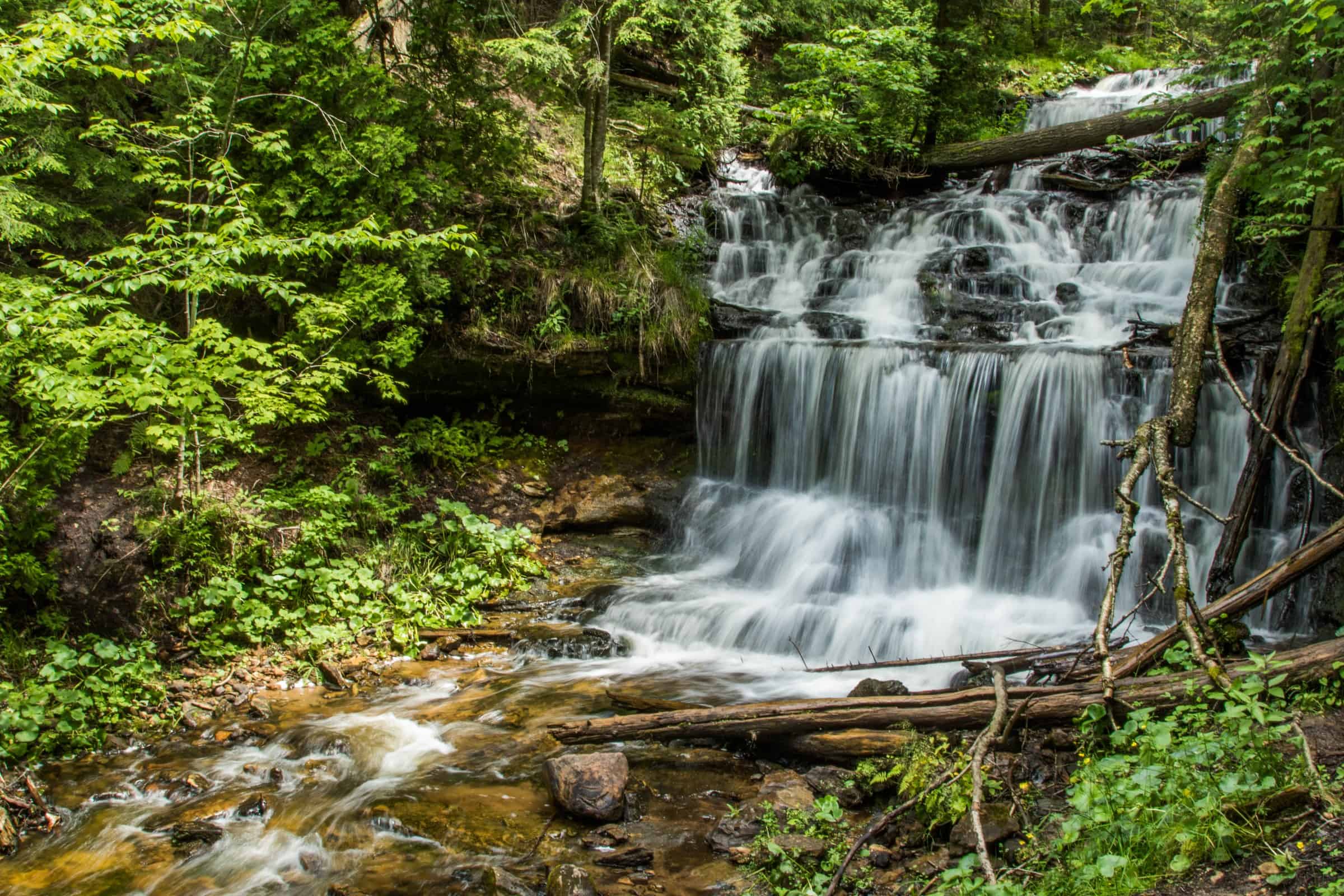
The falls sit inside the 23-acre Wagner Falls Scenic Site, run by the Michigan DNR’s Parks and Recreation Division. The DNR also lists the site as a Legally Dedicated Natural Area.

A Very Short Walk
From the lot, a 0.1-mile packed-gravel trail and boardwalk runs to an observation platform above the falls. There are a few steps on the way. A travel feature published by Islands in April 2026 says the trail from the parking lot is “only half a mile,” while the DNR’s own listing puts it at 0.1 mile. The National Park Service, which lists the falls on its Pictured Rocks pages, lands in between at 0.2 mile.
Leave the hiking boots in the trunk if you like. That same Islands piece also gives the site 22 acres, where the DNR says 23.
Why the Water Falls Here
Wagner Creek cascades over rock ledges here before emptying into the Anna River, according to the DNR. The reason is a sandwich of rock. A hard, resistant cap rock of siliceous dolomite sits on top of a much weaker sandstone that erodes easily, and the DNR says that pairing is behind the ledges and waterfalls throughout this region.
The state has been writing this spot down for a long time. A 1956 Michigan Geological Survey index of reported rock exposures lists Wagner Falls in Munising Township with two rock names beside it: Hermansville, and Munising under Lake Superior Sandstone.
Two years later, geologist W.K. Hamblin published The Cambrian Sandstones of Northern Michigan as Michigan Geological Survey Publication 51. According to the U.S. Geological Survey’s geologic names database, Hamblin proposed the name Au Train formation for rocks “which had been included under Hermansville limestone.” The type locality for that name is Au Train Falls, also in Alger County. So the Hermansville label on the 1956 Wagner Falls entry is the one the state’s own survey renamed two years later.

Go in Winter, or in October
The Park Service is blunt about the best season. “This is a particularly stunning waterfall in winter, popular with local artists and photographers,” its page says, and the parking lot is generally plowed in winter and accessible by most vehicles. The DNR, for its part, calls the site an outstanding scenic spot during the color season.
The Other Falls Down the Road
Munising’s visitors bureau places Wagner Falls just past the junction of M-94 and M-28, close to Alger Falls. The Alger County Chamber of Commerce describes Alger Falls as “a small roadside waterfall just outside of Munising.” It also warns that “by mid summer it gets pretty thin,” so late summer visitors may find Alger running light.
Do both in one stop. They are practically neighbors.
Before You Park
The lot holds 8 to 10 cars, so a full lot means a short wait. There are no restrooms or water on site. Leashed pets are allowed.
Sources: Michigan Department of Natural Resources; National Park Service; Michigan Geological Survey Division (Publication 50, 1956); U.S. Geological Survey National Geologic Map Database; Munising Visitors Bureau; Alger County Chamber of Commerce; Islands.
Go See It
Wagner Falls Scenic Site, Munising
- Hours
- 8 a.m. to 10 p.m. daily (Michigan state park day-use hours)
- Cost
- Recreation Passport required for vehicle entry: $15 Michigan resident vehicle at plate renewal; nonresident $42 annual or $12 daily
- Season
- Year-round access per NPS winter note (lot generally plowed); DNR recommends fall color season
- Drive
- From Marquette: 48 min (44.3 mi) via M-28 E
From the Bridge: 1 hr 56 min (120 mi) via US-2 W and M-28 W
More worth reading


Sources, credits, and reporting details
Sources & accountability
How this story was reported
Editorial methodAggregation
Last verifiedSep. 28, 2026
Corrections statusNo material correction note is recorded on this article.
AI assistanceResearched and drafted with AI tools. Reviewed and approved by editor Keegan O’Brien.
Verification note: Sources read and checked Sept. 28, 2026.
Primary sources
-
Wagner Falls Scenic Site — Munising Visitors Bureau
Accessed Sep. 28, 2026.
Supports: Falls are 20 feet high
"Wagner Falls is a beautiful and easily accessible waterfall with a height of 20 feet."
-
Waterfalls — Alger County Chamber of Commerce (Greater Munising Bay)
Accessed Sep. 28, 2026.
Supports: Wagner Falls height 20 ft (corroboration)
"Height: 20ft"
-
Wagner Falls Scenic Site (Recreation Search) — Michigan Department of Natural Resources
Accessed Sep. 28, 2026.
Supports: 0.1-mile packed-gravel trail and boardwalk to observation platform; 1.5 miles south of Munising
"Discover the beauty of Wagner Falls, located just 1.5 miles south of Munising. A 0.1-mile packed-gravel trail and boardwalk lead to an observation platform overlooking cascading waterfall."
-
Wagner Falls Scenic Site (Recreation Search) — Michigan Department of Natural Resources
Accessed Sep. 28, 2026.
Supports: A few steps on the trail
"A packed-gravel trail and boardwalk with a few steps leads from the parking area to an observation platform overlooking Wagner Falls."
-
Wagner Falls Scenic Site (Recreation Search) — Michigan Department of Natural Resources
Accessed Sep. 28, 2026.
Supports: Directions: M-28 East 1.2 mi, right on M-94 West 0.3 mi, lot for 8-10 cars
"From Munising, follow M-28 East for 1.2 miles, then turn right onto M-94 West. Continue for .3 miles and turn left into to a small parking area for 8-10 cars."
-
Wagner Falls Scenic Site (Recreation Search) — Michigan Department of Natural Resources
Accessed Sep. 28, 2026.
Supports: No restrooms or water
"Please note: no restrooms or water are available on-site."
-
Wagner Falls Scenic Site (Recreation Search) — Michigan Department of Natural Resources
Accessed Sep. 28, 2026.
Supports: GPS coordinates
GPS listed on page: 46.387526, -86.646904 (WebFetch extraction; coordinates shown as data, not a sentence)
-
Wagner Falls Scenic Site (Natural Areas) — Michigan Department of Natural Resources
Accessed Sep. 28, 2026.
Supports: 23 acres; managed by DNR Parks & Recreation Division; Legally Dedicated Natural Area
Page fields: "23 acres"; "DNR Parks & Recreation Division"; "Legally Dedicated Natural Area"
-
Wagner Falls Scenic Site (Natural Areas) — Michigan Department of Natural Resources
Accessed Sep. 28, 2026.
"The Wagner Creek cascades over rock ledges in this area before emptying into the Anna River, creating a beautiful scenic spot. The ledges and waterfalls that occur in this area, and throughout this region, are due to its underlying geology: a hard, resistant cap rock (siliceous dolomite) that overlays a much weaker and more easily eroded sandstone."
-
Wagner Falls Scenic Site (Natural Areas) — Michigan Department of Natural Resources
Accessed Sep. 28, 2026.
Supports: Outstanding scenic spot in color season
"This is an outstanding scenic spot during the color season."
-
Wagner Falls — National Park Service (Pictured Rocks National Lakeshore)
Accessed Sep. 28, 2026.
Supports: One of the few area waterfalls easily accessed by regular vehicles in winter
"Wagner Falls is one of the few waterfalls of the area easily accessed by regular vehicles in winter"
-
Wagner Falls — National Park Service (Pictured Rocks National Lakeshore)
Accessed Sep. 28, 2026.
Supports: NPS gives 0.2 mile walk
"A 0.2 mile forested walk leads from the parking area along a hard-packed gravel/boadwalk trail to the viewing platform for the falls."
-
Wagner Falls — National Park Service (Pictured Rocks National Lakeshore)
Accessed Sep. 28, 2026.
Supports: Stunning in winter, popular with artists and photographers
"This is a particularly stunning waterfall in winter, popular with local artists and photographers."
-
Wagner Falls — National Park Service (Pictured Rocks National Lakeshore)
Accessed Sep. 28, 2026.
Supports: Lot generally plowed in winter
"The parking lot is generally plowed in winter and accessible by most vehicles."
-
Wagner Falls — National Park Service (Pictured Rocks National Lakeshore)
Accessed Sep. 28, 2026.
Supports: Leashed pets allowed; lot for 8-10 cars
"Leashed pets allowed." / "Turn left into the small parking area for 8-10 cars."
-
Publication 50: An Index of the Geology of Michigan 1823-1955 (Reported Exposures of Paleozoic Rocks) — Michigan Department of Conservation, Geological Survey Division
Accessed Sep. 28, 2026.
Supports: 1956 state index lists Wagner Falls with Hermansville and Munising (Lake Superior Sandstone)
"Munising Twp., NW NE sec. 14, T46N, R19W. Wagner Falls. Hermansville. Lake Superior Sandstone: Munising."
-
Geolex: Au Train publications — U.S. Geological Survey, National Geologic Map Database
Accessed Sep. 28, 2026.
Supports: Hamblin 1958, Michigan Geological Survey Publication 51
"Hamblin, W.K., 1958, The Cambrian sandstones of northern Michigan: Michigan Geological Survey Publication, no. 51, 146 p."
-
Geolex: Au Train publications — U.S. Geological Survey, National Geologic Map Database
Accessed Sep. 28, 2026.
"Hamblin, following Grabau (1906), proposes that Au Train formation be used for these rocks, which had been included under Hermansville limestone." / "Au Train Falls, in Alger Co., northern MI, where rocks are best exposed and sections are thickest"
-
Wagner Falls — Munising Visitors Bureau
Accessed Sep. 28, 2026.
Supports: Location just past M-94/M-28 junction, close to Alger Falls
"Located south of Munising on M-94, just past the junction of M-94 and M-28 (close to Alger Falls)."
-
Waterfalls — Alger County Chamber of Commerce (Greater Munising Bay)
Accessed Sep. 28, 2026.
Supports: Alger Falls description and summer flow
"This is a small roadside waterfall just outside of Munising." / "By mid summer it gets pretty thin."
-
Rules and regulations — Michigan Department of Natural Resources
Accessed Sep. 28, 2026.
Supports: Day-use hours 8 a.m. to 10 p.m.
"State parks and recreation area day-use hours are open 8 a.m. to 10 p.m. daily."
-
Rules and regulations — Michigan Department of Natural Resources
Accessed Sep. 28, 2026.
Supports: Recreation Passport required for vehicle entry into scenic sites
"A Recreation Passport is required for vehicle entry into state parks, recreation areas, state forest campgrounds and scenic sites, as well as DNR-managed boating access sites, state forest campgrounds and designated trailhead parking."
-
Recreation Passport — Michigan Department of Natural Resources
Accessed Sep. 28, 2026.
Supports: $15 resident vehicle; $42 nonresident annual; $12 nonresident daily
"Vehicles $15 when purchased at time of license plate registration renewal through the Secretary of State." / "Annual $42" / "Daily $12 – good for entry and re-entry to any state park for the day."
-
Google Maps driving directions from Marquette — Google Maps
Accessed Sep. 28, 2026.
Supports: Go See It / Drive: 48 min, 44.3 miles via M-28 E
Read live in Chrome Sep 28, 2026 (Monday): "48 min 44.3 miles via M-28 E" (fastest route shown).
-
Google Maps driving directions from Mackinac Bridge — Google Maps
Accessed Sep. 28, 2026.
Supports: Go See It / Drive: 1 hr 56 min, 120 miles via US-2 W and M-28 W
Read live in Chrome Sep 28, 2026 (Monday): "1 hr 56 min 120 miles via US-2 W and M-28 W" (fastest route shown).
Additional reporting
-
Michigan's Smallest State Park Features An Easy Walk To A Lovely Waterfall (syndicated on AOL) — Islands (David McElhinney)
Published Apr. 4, 2026. Accessed Sep. 28, 2026.
Supports: CORRECTED CLAIM: trail half a mile; 22 acres
"The trail from the parking lot is only half a mile" / "At 22 acres, it's the smallest state park in Michigan" (contradicted by DNR "0.1-mile" trail and "23 acres")
-
CALCULATED — YooperHub
Accessed Sep. 28, 2026.
Supports: "Two years later" (1956 index to 1958 Hamblin)
CALCULATED: 1958 minus 1956 = 2 years.
-
CALCULATED — YooperHub
Accessed Sep. 28, 2026.
Supports: "A tenth of a mile" = DNR 0.1-mile trail
CALCULATED: 0.1 mile expressed as a tenth of a mile.
-
Wagner Falls Scenic Site — Wikipedia
Accessed Sep. 28, 2026.
Supports: Corroborates 23 acres, DNR-run, near M-28/M-94
"23-acre (0.1 km2)"; "a Michigan State Park, located in central Alger County, Upper Michigan"
-
Alger Falls — Wikipedia
Accessed Sep. 28, 2026.
Supports: Alger Falls location at M-28/M-94 junction
"Alger Falls is a waterfall located along highway M-28 (Michigan highway) in Alger County, Michigan near Munising at the junction with M-94."
Photo and media credits
-
Wagner_Falls_(36003612295).jpg?utm_source=commons.wikimedia.org&utm_campaign=imageinfo&utm_content=original (featured, media 3828) — Wikimedia Commons / LadyDragonflyCC
Featured image record. Published Jul. 15, 2017. Accessed Sep. 28, 2026. CC BY 2.0.
Supports: Image credit and licence.
Licence read off the source page Sep 28, 2026; 5472×3648 original, uploaded as 2400×1600 (downscale). Caption and alt carry the credit.
-
Wagner_Falls.jpg?utm_source=commons.wikimedia.org&utm_campaign=imageinfo&utm_content=original (media 3829) — Wikimedia Commons / Two Hearted River
Published Apr. 22, 2006. Accessed Sep. 28, 2026. CC BY-SA 3.0.
Supports: Image credit and licence.
Licence read off the source page Sep 28, 2026; 2288×1712 original, uploaded as 2288×1712 (downscale). Caption and alt carry the credit.
-
Wagner_Falls_Scenic_Site_sign.jpg?utm_source=commons.wikimedia.org&utm_campaign=imageinfo&utm_content=original (media 3830) — Wikimedia Commons / NMMIMAJ
Published Jun. 15, 2012. Accessed Sep. 28, 2026. CC BY-SA 3.0.
Supports: Image credit and licence.
Licence read off the source page Sep 28, 2026; 3008×2000 original, uploaded as 2400×1596 (downscale). Caption and alt carry the credit.
.jpg)

