Piers Gorge is a deep gorge cut by the Menominee River between Michigan and Wisconsin, and granite boulders inside it churn out Class III rapids, according to the City of Norway. The river tumbles over four rocky ledges known as piers. The biggest drop, Misicot Falls, sits just past the quarter-mile mark of a trail that starts at the parking lot.
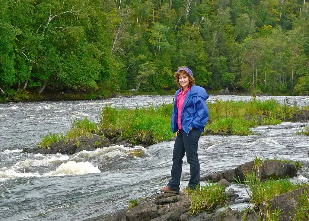
From 1983 through 1997, the gorge hosted the World Cup Kayak Races, the city says. Today, rafters ride the same water while hikers watch from the bank.

Four Piers, One Big Drop
A well-kept trail on the Michigan bank runs past all four piers, according to the waterfall guide GoWaterfalling. The first pier is a short distance from the parking area, and the second is a quarter mile down the trail. Misicot Falls comes right after, where the river spills over a ledge GoWaterfalling puts at about 8 feet. The World Waterfall Database says lidar data suggests a drop of about 5 feet, and lists Misicot as the official name, with Mishicot also in use.
The last pier, Sand Portage Falls, sits a full mile past Misicot. American Whitewater passes along a legend that the rocks there were worn into sand by Native people portaging around the gorge on the river’s left bank. Michigan Backroads says the trail itself was first used by Native Americans to portage around the falls.
Where the Name Comes From
Accounts split on the name. GoWaterfalling says the gorge is named for the natural rocky “piers” the river tumbles over. Wildman Adventure Resort, a rafting outfitter, tells a logging story instead. It says companies floating white pine logs to downstream mills built wooden piers and guide structures along the banks to steer the logs through this stretch.

Who Runs It Now
The gorge sat on power company land that had always been open to the public through cooperation with We Energies, The Daily News in Iron Mountain reported in 2013. Plenty of travel pages call it Piers Gorge State Park. The Michigan DNR lists it as the Piers Gorge Unit, the northern end of the Menominee River State Recreation Area, which Michigan and Wisconsin comanage. The DNR puts the whole park at 7,652 acres along a 17-mile stretch of undeveloped river.
Michigan’s side was created on November 10, 2011, when DNR Director Rodney Stokes authorized buying 2,354 acres from the Wisconsin Electric Power Company for $2,534,400, according to Wikipedia. An attendant now staffs the Piers Gorge entrance, which the City of Norway says is expected to help public safety and the local economy. The DNR lists three outfitters running rafting trips in the park: Kosir’s Rapid Rafts, True North Outpost and Wildman Adventure Resort.
Seeing all four piers is about a 3-mile walk out and back, and Sand Portage Falls sits about 1.3 miles from the parking area. The paths are rocky, slippery when wet and crossed by old tree roots, so this is a boots outing. Wildman Adventure Resort runs its rafting trips from mid-May to early October, which puts this weekend at the very tail of the season, so call before you count on a ride.
Sources: City of Norway, Piers Gorge page; Michigan DNR, Menominee River State Recreation Area page; Wisconsin DNR, Menominee River State Recreation Area basic information; Downtown Norway, Piers Gorge State Recreation Area page; GoWaterfalling, Piers Gorge; World Waterfall Database, Misicot Falls; American Whitewater, Menominee River Piers Gorge reach; Michigan Backroads, Piers Gorge; Wildman Adventure Resort, “What to Do in Piers Gorge State Park”; Bill Ziegler, “Dickinson waterfalls rich in beauty, history,” The Daily News (Iron Mountain), May 6, 2013; Wikipedia, Menominee River State Recreation Area.
Go See It
Piers Gorge, Norway
- Hours
- Open year-round, 6 a.m. to 11 p.m. (Wisconsin DNR listing for the recreation area)
- Cost
- Recreation Passport required for vehicle entry (Michigan DNR); an attendant staffs the entrance
- Season
- Open year-round. Outfitter rafting trips run mid-May to early October.
- Drive
- From Marquette: 1 hr 41 min (89.3 mi) via M-95 S
From the Bridge: 3 hr 12 min (190 mi) via US-2 W
More worth reading


Sources, credits, and reporting details
Sources & accountability
How this story was reported
Editorial methodAggregation
Last verifiedOct. 4, 2026
Corrections statusNo material correction note is recorded on this article.
AI assistanceResearched and drafted with AI tools. Reviewed and approved by editor Keegan O’Brien.
Verification note: Sources read and checked Sept. 26, 2026; drive times re-read Oct. 4, 2026.
Primary sources
-
Piers Gorge — City of Norway
Accessed Sep. 26, 2026.
Supports: Piers Gorge is a deep gorge cut by the Menominee River between Michigan and Wisconsin
"Piers is a deep gorge cut by the Menominee River between Michigan and Wisconsin."
-
Piers Gorge — City of Norway
Accessed Sep. 26, 2026.
Supports: Granite boulders produce Class III rapids
"Granite boulders give the river its rush, helping to produce Class III rapids."
-
Piers Gorge — City of Norway
Accessed Sep. 26, 2026.
Supports: World Cup Kayak Races held at Piers Gorge 1983 through 1997
"Piers Gorge was the site of the World Cup Kayak Races from 1983 through 1997."
-
Menominee River State Recreation Area — Michigan DNR
Accessed Sep. 26, 2026.
Supports: Correct name: Piers Gorge Unit, northern unit of Menominee River State Recreation Area
"There are three units in the park, including Piers Gorge Unit in the north and the Quiver Falls Unit and Pemene Falls Unit in the south."
-
Menominee River State Recreation Area — Michigan DNR
Accessed Sep. 26, 2026.
Supports: Comanaged by Michigan and Wisconsin
"Menominee River State Recreation Area is comanaged by the states of Michigan and Wisconsin."
-
Menominee River State Recreation Area — Michigan DNR
Accessed Sep. 26, 2026.
Supports: 7,652 acres; 17-mile stretch of undeveloped river corridor
"The park is home to a beautiful, 17-mile stretch of undeveloped river corridor that straddles the banks of the Menominee River in both Michigan and Wisconsin. The 7,652-acre park features rocky gorges, towering pines and wide-open stretches"
-
Piers Gorge — City of Norway
Accessed Sep. 26, 2026.
Supports: Attendant staffs entrance; expected to help public safety and local economy
"There is now an attendant regularly staffing the entrance to Piers Gorge. … This project is expected to have a positive impact on public safety and on our local economy."
-
Menominee River State Recreation Area — Michigan DNR
Accessed Sep. 26, 2026.
Supports: Three rafting outfitters: Kosir's Rapid Rafts, True North Outpost, Wildman Adventure Resort
"Kosir's Rapid Rafts, True North Outpost and Wildman Adventure Resort offer whitewater rafting trips in the park."
-
Menominee River State Recreation Area — Michigan DNR
Accessed Sep. 26, 2026.
Supports: Go See It / Where: GPS coordinates
"45.75969776,-87.93896914"
-
Piers Gorge — City of Norway
Accessed Sep. 26, 2026.
Supports: Go See It / Getting there: road is unpaved
"Look for this sign, waiting not far out of town on US 8. Let the unpaved road lead you to its end, where this gorgeous place awaits."
-
Basic Information | Menominee River State Recreation Area — Wisconsin DNR
Accessed Sep. 26, 2026.
Supports: Go See It / Hours and Season: open year-round 6 a.m. to 11 p.m.
"The Menominee River State Recreation Area is open year-round from 6 a.m. to 11 p.m."
-
Menominee River State Recreation Area — Michigan DNR
Accessed Sep. 26, 2026.
Supports: Go See It / Cost: Recreation Passport required for vehicle entry
"A Recreation Passport (park pass) is required for vehicle entry into all state park and forest campgrounds."
-
Piers Gorge — City of Norway
Accessed Sep. 26, 2026.
Supports: Go See It / Cost: attendant staffs the entrance
"There is now an attendant regularly staffing the entrance to Piers Gorge."
-
Piers Gorge — City of Norway
Accessed Sep. 26, 2026.
Supports: Go See It / Trail: tree roots across the trail
"Old tree roots tangle their way across the ground, making for a tricky trail."
-
Google Maps directions, Marquette to Piers Gorge — Google Maps
Accessed Oct. 4, 2026.
Supports: Drive time from Marquette
Fastest route read live Oct 4, 2026: 1 hr 41 min (89.3 mi) via M-95 S.
-
Google Maps directions, Mackinac Bridge to Piers Gorge — Google Maps
Accessed Oct. 4, 2026.
Supports: Drive time from Mackinac Bridge
Fastest route read live Oct 4, 2026: 3 hr 12 min (190 mi) via US-2 W.
Additional reporting
-
Piers Gorge State Recreation Area — Downtown Norway
Accessed Sep. 26, 2026.
Supports: Rafters ride the rapids while visitors watch
"stop to enjoy the breathtaking views and watch whitewater rafters ride the rapids."
-
Piers Gorge — GoWaterfalling
Accessed Sep. 26, 2026.
Supports: Named for natural rocky piers; four sets of rapids
"It is named for natural rocky "piers" that the river tumbles over, resulting in four sets of rapids, some of which could be classified as low falls."
-
Piers Gorge — GoWaterfalling
Accessed Sep. 26, 2026.
Supports: Trail on Michigan side passes all four piers
"A well maintained trail on the Michigan side of the river takes you past the four piers."
-
Piers Gorge — GoWaterfalling
Accessed Sep. 26, 2026.
Supports: First pier a short distance from parking area
"The first pier is a short distance from the parking area"
-
Piers Gorge — GoWaterfalling
Accessed Sep. 26, 2026.
Supports: Second pier a quarter mile down the trail; Misicot (Mishicot) Falls just beyond
"A quarter mile down the trail brings you to the much more scenic second pier. It is a small falls with a drop of a few feet. Just beyond this is Mishicot Falls."
-
Piers Gorge — GoWaterfalling
Accessed Sep. 26, 2026.
Supports: Biggest drop about 8 feet, Mishicot Falls
"The biggest of the drops is about 8' high and is named Mishicot Falls."
-
Misicot Falls — World Waterfall Database
Accessed Sep. 26, 2026.
Supports: Lidar suggests about a 5-foot drop
"Lidar data suggests a drop of approximately 5 feet (2 meters)."
-
Misicot Falls — World Waterfall Database
Accessed Sep. 26, 2026.
Supports: Misicot is the official name; Mishicot also used
"Misicot Falls is the Official name of this waterfall. The name of this waterfall is also sometimes spelled Mishicot, both variants seem to be acceptable."
-
Piers Gorge — GoWaterfalling
Accessed Sep. 26, 2026.
Supports: Last pier, Sand Portage Falls, a full mile past Misicot
"The last pier is a full mile past Mishicot Falls. This one is named Sand Portage Falls."
-
Menominee – A) Piers Gorge: Niagara to Hwy.8 — American Whitewater
Accessed Sep. 26, 2026.
Supports: Sand Portage name legend: portaging wore rocks into sand, trail on river left
"The legend is this was known as Sand Portage because the Indians wore the rocks into sand with the countless times they used the trail on river left to portage the gorge."
-
Piers Gorge — Michigan Backroads
Accessed Sep. 26, 2026.
Supports: Trail first used by Native Americans to portage around the falls
"The trail was first used by Native Americans to portage around the falls"
-
What to Do in Piers Gorge State Park — Wildman Adventure Resort
Published Apr. 25, 2026. Accessed Sep. 26, 2026.
"The name 'Piers Gorge' comes directly from that era. Massive white pine logs were floated down the Menominee River toward downstream mills, but the gorge section—narrow, rocky, and fast-moving—was one of the most dangerous stretches. To guide logs safely through, logging companies built wooden piers and guide structures along the riverbanks."
-
Dickinson waterfalls rich in beauty, history — The Daily News (Iron Mountain), Bill Ziegler
Published May. 6, 2013. Accessed Sep. 26, 2026.
Supports: Land had always been open to the public through cooperation with We Energies
"Piers Gorge and Sand Portage Falls were recently purchased by the Michigan and Wisconsin DNRs although it had always been open to the public through cooperation with We Energies."
-
What to Do in Piers Gorge State Park — Wildman Adventure Resort
Published Apr. 25, 2026. Accessed Sep. 26, 2026.
Supports: Travel/outfitter pages call it Piers Gorge State Park (the error being corrected)
"What to Do in Piers Gorge State Park"
-
Menominee River State Recreation Area — Wikipedia
Accessed Sep. 26, 2026.
"The Menominee River State Recreation Area was officially created on November 10, 2011, when DNR Director Rodney Stokes authorized the purchase of 2,354 acres (953 ha) of Wisconsin Electric Power Company land along the Menominee River which forms the boundary between Michigan and Wisconsin. The total purchase price for the acreage on the Michigan side of the river was $2,534,400"
-
Piers Gorge — GoWaterfalling
Accessed Sep. 26, 2026.
Supports: Go See It / Where: end of Piers Gorge Road, west of US 8, just north of the border
"Piers Gorge is located at the end of Piers Gorge Road, west of US 8 just north of the Michigan/Wisconsin border."
-
Dickinson waterfalls rich in beauty, history — The Daily News (Iron Mountain), Bill Ziegler
Published May. 6, 2013. Accessed Sep. 26, 2026.
Supports: Go See It / Getting there: 1.8 miles south of US-2/US-8, west on Piers Gorge Road just over a mile
"It can be easily accessed by driving south 1.8 miles from the intersection of U.S. 2 and U.S. 8 in Norway to Piers Gorge Road. Turn west (right) on Piers Gorge Road and travel just over a mile to a parking lot and trail head."
-
What to Do in Piers Gorge State Park — Wildman Adventure Resort
Published Apr. 25, 2026. Accessed Sep. 26, 2026.
Supports: Go See It / Season: rafting mid-May to early October
"At Wildman Adventure Resort, we run guided whitewater rafting trips down the Menominee River from mid-May to early October."
-
Piers Gorge — GoWaterfalling
Accessed Sep. 26, 2026.
Supports: Go See It / Trail: about 3 miles out and back
"A 3 mile out and back hike takes you past a number of rapids and small falls on the wide Menominee River."
-
Dickinson waterfalls rich in beauty, history — The Daily News (Iron Mountain), Bill Ziegler
Published May. 6, 2013. Accessed Sep. 26, 2026.
Supports: Go See It / Trail: Sand Portage Falls about 1.3 miles from parking
"The Sand Portage Falls at the head of Piers Gorge is farther upstream about 1.3 miles from the parking area."
-
Piers Gorge State Recreation Area — Downtown Norway
Accessed Sep. 26, 2026.
Supports: Go See It / Trail: rocky and slippery when wet
"Watch your step – some of the paths are rocky and slippery when wet."
Photo and media credits
-
First Pier in Piers Gorge (featured, media 2999) — Flickr / Tatiana12
Featured image record. Published Sep. 4, 2010. Accessed Sep. 26, 2026. CC BY 2.0.
Supports: Image credit and licence.
Flickr photo page read Sep 26: CC BY 2.0, taken Sept. 4, 2010; 1024×732.
-
Piers Gorge rapids (media 3931) — Flickr / Seclusive Nature
Published Dec. 26, 2020. Accessed Sep. 30, 2026. CC BY-SA 4.0.
Supports: Image credit and licence.
Flickr photo page read Sep 30: CC BY-SA 4.0 (licence link on the page). Placement: Flickr title "Mishicot Falls"; description: "The Piers Gorge unit of the Menominee River has four sets of rapids/falls." Taken Dec. 26, 2020. Uploaded at 1600×1200 (original 4032×3024).
-
Piers Gorge whitewater (media 3932) — Flickr / Seclusive Nature
Published Dec. 26, 2020. Accessed Sep. 30, 2026. CC BY-SA 4.0.
Supports: Image credit and licence.
Flickr photo page read Sep 30: CC BY-SA 4.0 (licence link on the page). Placement: Flickr title "Turbulence"; description: "Mishicot Falls in the Piers Gorge unit of the Menominee River Recreation Area." Taken Dec. 26, 2020. Uploaded at 1600×900 (original 1920×1080).