There is a roadside park on US-41 in Baraga County with a picnic table, a vault toilet, and a parking lot that looks like every other rest stop in the Upper Peninsula.
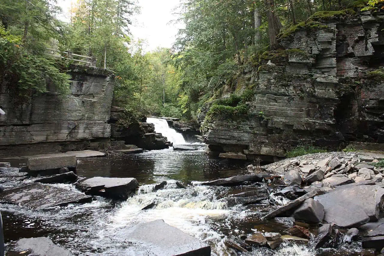
Ten minutes down the trail behind it, the ground drops away into a slate canyon.

What the river did
The Sturgeon River has spent thousands of years cutting into slate here, and the rock has broken along straight fault lines rather than eroding into a soft V. The result is unusually squared-off — a box canyon, with walls that look cut rather than worn.
Canyon Falls itself is about a 15-foot drop into that gorge. It is not the tallest waterfall in the state and does not try to be. What makes people stop mid-trail is the shape of the container it falls into.
Smaller drops sit upstream and down, and the first of them shows up just a few hundred feet from the trailhead. The main falls are roughly a mile in, on level ground the whole way.
About that nickname
Every sign and blog calls this the Grand Canyon of Michigan, and the phrase does a lot of work getting people off the highway.
The honest version: the roadside stop is the small end of the feature. Keep going downstream, well past where the maintained trail quits, and the gorge widens into the Sturgeon River Gorge Wilderness — a 14,729-acre unit of the Ottawa National Forest established in 1987, where the canyon runs up to a mile across and hundreds of feet deep. That is the part that actually earns the comparison, and almost nobody who stops at the roadside park ever sees it.

Where the trail stops being easy
This is worth knowing before you arrive with kids and flip-flops.
The mile to the main falls is flat, well marked, and family-friendly — it is also part of the North Country National Scenic Trail, the 4,800-mile route running across eight states from North Dakota to Vermont. There is a viewing platform with a railing at the falls.
Past that platform, the maintained trail ends. An unmarked path follows the rim of the gorge, and it turns steep, rough, and root-tangled. The slate is genuinely slick when wet, and there are long drops directly off the rim with nothing between you and them.
People do climb over the railing for photographs, and people do jump into the river from the ledges. We are not going to pretend that is not happening. We are also not going to recommend it: this is unpatrolled backcountry above hard rock, water depth changes with flow, and there is no fast way to get help in there. The state closed Houghton-Douglass Falls for years after exactly this kind of scrambling went wrong.
Before you park
Canyon Falls Roadside Park is on US-41 roughly 15 miles south of L’Anse, near Alberta, a few miles north of where US-41 meets M-28. It is well signed and free, with parking, restrooms, and interpretive signs at the trailhead.
Wear real shoes. The lot is not plowed in winter, so cold-season visitors park along the road — and the frozen gorge is worth the trip if you are equipped for it.
If you are collecting waterfalls on this run, we have a broader list of the best in the U.P.
Go See It
Canyon Falls Roadside Park
- Hours
- Open dawn to dusk; the roadside park itself is accessible off US-41 year-round.
- Cost
- Free.
- Season
- Year-round via US-41, though the trail can ice over in winter.
- Drive
- From Marquette: 1 hr 2 min (57.5 mi) via US-41 N
From the Bridge: 3 hr 40 min (221 mi) via US-2 W and M-28 W
More worth reading


Yooper Hub community
The conversation
Know something this story missed? Corrections and additions get read by an editor and folded into the article, with credit.
Real neighbors, real names. A Yooper Hub editor reads your first comment before it appears; after that you’re a known neighbor and your comments post right away. No account required. Community guidelines
1 comment
This is really old info. The trail from the parking lot is rugged to the falls and railing. Never crawl over the railing. People have lost their life there doing that. No one jumps from that railing spot, their jump spot is a longer hike west of that railing. Hiking past the railing is a well marked rugged trail that goes west all the way to the Lewis and Clark trail in North Dakota. If you follow the rugged but well marked trail east under that hiway bridge you have pictured you can hike about 85 miles to marquette and continue east to the Appalachian trail in Vermont.
This North Country National Scenic trail is nearly 5,000 miles long crossing 8 states. The North Country Trail has more off road miles than the Appalachian trail is long.
Sources, credits, and reporting details
Sources & accountability
How this story was reported
Editorial methodAggregation
Last verifiedAug. 15, 2026
Corrections statusNo material correction note is recorded on this article.
AI assistanceResearched and drafted with AI tools. Reviewed and approved by editor Keegan O’Brien. Tool: Claude Opus 5.
Verification note: Ledger reconstructed 2026-08-15. The piece is a place explainer built from the county visitors bureau, the North Country Trail signage at the roadside park, and regional waterfall guides; the numbers (a 15-foot drop, the slate gorge, the mile-long trail) are consistent across them.
Primary sources
-
Canyon Falls — Copper Country / Keweenaw visitors information
Accessed Aug. 15, 2026.
-
Canyon River Falls on Sturgeon River — Waterfalls of the Keweenaw
Accessed Aug. 15, 2026.
Additional reporting
-
Sturgeon River Gorge Wilderness — Wikipedia contributors
Accessed Aug. 15, 2026.
Supports: The wilderness downstream that the gorge widens into; the Sturgeon's length and course.
Pointer to the Forest Service designation.
-
Canyon Falls Roadside Park — Michigan Trails
Accessed Aug. 15, 2026.
Photo and media credits
-
Canyon Falls (featured image) — Alan Wilcox, via Wikimedia Commons
Featured image record. Accessed Aug. 2, 2026. CC0.
Creator and license from the attachment caption. Attachment 2106, 1280×854.