The Tower of History rises 210 feet over Sault Ste. Marie, a concrete and glass spike the Catholic Church built in 1968 as the Shrine of the Missionaries. It was meant to be one piece of a much larger complex. The rest of that complex never got built.
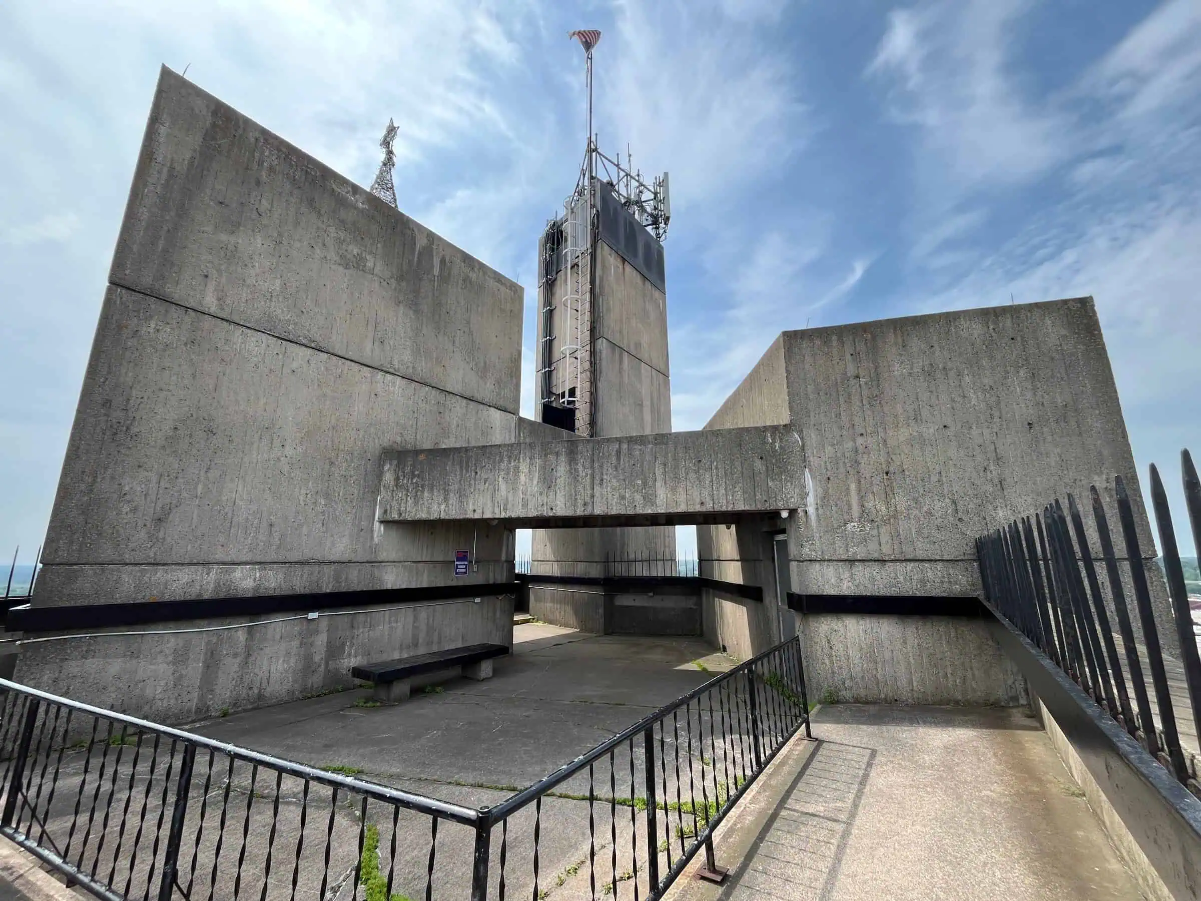
What stands today is the part they finished: three trapezoid-shaped columns, an express elevator and viewing platforms hanging over the Soo Locks. Sault Historic Sites says the view from the top covers up to 1,200 square miles, including the locks, the St. Marys River and the Canadian wilderness. The 2026 season ends October 17, so the window is closing.

A Steeple for the Missionaries
The parish behind it was St. Mary’s, which traces its roots to 1668, when Jacques Marquette founded the Sainte-Marie Mission at the rapids. In 1968 the people of St. Mary’s had a bell tower constructed that also served as a shrine to the many missionaries who served the church. Paul Sabourin, curator for Sault Historic Sites, told SooLeader it honored early missionaries like the venerable Bishop Frederic Baraga.
The shape carries its own theology. There are three balconies on the tower, and Sabourin said they represent the three crosses on Calvary, or the Father, Son and Holy Spirit. The design came from George Rafferty of Progressive Design Associates in Saint Paul, Minnesota.
The Budget Climbed Faster Than the Elevator
The money is where the plan came apart. Wikipedia, drawing on 1970s Michigan newspaper coverage, says the tower was first estimated at just $50,000 and ended up costing nearly $1 million. Sabourin describes it as a $600,000 commitment with an end result of over $1 million.
A new church building and community center were supposed to go up alongside it, but St. Mary’s ended funding for the project. In 1971 the Roman Catholic Diocese of Marquette took responsibility for the tower because of the parish’s money problems. Wikipedia adds that the unforeseen oil crisis took out the tourism growth the planners expected.
Who Actually Got It
In 1980 the diocese let it go. Roadside America says the church gave the tower to the city, which gave it a new name. The operator tells it differently: the Shrine of the Missionaries was donated to Sault Historic Sites, incorporated as Le Sault De Sainte Marie Historical Sites, Inc., in 1980 and has run as the Tower of History ever since.
Wikipedia backs the 1980 date and cites a March 1980 Lansing State Journal story headlined “Diocese donates tower to civic group.” Even the parish’s own history page is off by a year, dating the handoff to 1981.
The name changed along the way. It started as the Tower of Missionaries and was renamed the Tower of History to broaden its appeal. The exhibits still tell the missionary story, now widened to include local and Native American history.

The View From 210 Feet
An express elevator does the climbing, and Wikipedia clocks the ride to the viewing platforms at 45 seconds. Up top you get the St. Marys River, the rapids, the Soo Locks and the International Bridge into Canada. Pure Michigan says you can see the twin cities for 20 miles, and telescopes are available.
Those two numbers agree more than they look. By our own arithmetic, a circle 20 miles in radius covers about 1,257 square miles, right in line with the operator’s 1,200. Down in the lower level there is a mini-museum of Native American culture, so the trip covers the ground floor too.
Sources: Sault Historic Sites; Holy Name of Mary Parish; SooLeader; Sault Ste. Marie Convention and Visitors Bureau; Pure Michigan; Upper Peninsula Travel and Recreation Association; Roadside America; Wikipedia.
Go See It
Tower of History, Sault Ste. Marie
- Hours
- Through Oct 17, 2026: Mon to Sat 10 a.m. to 5 p.m.; Sun noon to 5 p.m.
- Cost
- Adults 18+ $8.75; ages 5 to 17 $4.50; Valley Camp + Tower combo $24.25 adult / $12.25 child
- Season
- May 8 to October 17, 2026
- Drive
- From Marquette: 2 hr 45 min (165 mi) via M-28 E
From the Bridge: 54 min (55.4 mi) via I-75 N
More worth reading


Sources, credits, and reporting details
Sources & accountability
How this story was reported
Editorial methodAggregation
Last verifiedSep. 28, 2026
Corrections statusNo material correction note is recorded on this article.
AI assistanceResearched and drafted with AI tools. Reviewed and approved by editor Keegan O’Brien.
Verification note: Sources read and checked Sept. 28, 2026.
Primary sources
-
Tower of History — Sault Historic Sites
Accessed Sep. 28, 2026.
Supports: Height 210 feet; views of the Soo Locks
"Soaring 210 feet above Sault Ste. Marie and the Soo Locks, the tower has observation platforms for visitors to get spectacular views"
-
Tower of History — Sault Historic Sites
Accessed Sep. 28, 2026.
Supports: Built 1968 by the Catholic Church as the Shrine of the Missionaries
"built in 1968 by the Catholic Church as the Shrine of the Missionaries."
-
Tower of History — Sault Historic Sites
Accessed Sep. 28, 2026.
Supports: Meant to be part of a larger complex
"The Shrine was meant to be part of a larger complex that would have featured exhibits about the early Missionaries such as Bishop Baraga."
-
Tower of History — Sault Historic Sites
Accessed Sep. 28, 2026.
Supports: Express elevator; view up to 1,200 square miles incl. locks, river, Canadian wilderness
"An express elevator whisks visitors to the top for a panoramic view of up to 1,200 square miles, including the Sault Locks, the St. Mary's River, and the Canadian wilderness."
-
Tower of History — Sault Historic Sites
Accessed Sep. 28, 2026.
Supports: Donated to Sault Historic Sites in 1980; operated as Tower of History since
"Shrine of the Missionaries was donated to the Sault Historic Sites in 1980. It has been operated as the Tower of History ever since."
-
Tower of History — Sault Historic Sites
Accessed Sep. 28, 2026.
Supports: Exhibits: missionaries, widened to local and Native American history
"The Tower of History remains true to its original mission of telling the tale of the early Missionaries, but its scope has been widened to include both local and Native American history."
-
Tower of History — Sault Historic Sites
Accessed Sep. 28, 2026.
Supports: Address 501 East Water Street
"501 East Water Street Sault Ste. Marie, MI 49783"
-
Tower of History Rates and Schedules — Sault Historic Sites
Accessed Sep. 28, 2026.
Supports: 2026 season May 8 to Oct 17; fall hours
"May 8 – June 11" … "September 6 – October 17: Monday-Saturday 10am-5pm; Sunday 12pm-5pm" (as rendered by fetch tool)
-
Tower of History Rates and Schedules — Sault Historic Sites
Accessed Sep. 28, 2026.
Supports: Admission adults $8.75, children 5-17 $4.50
"Adults (18+): $8.75" "Children (5-17): $4.50"
-
Tower of History Rates and Schedules — Sault Historic Sites
Accessed Sep. 28, 2026.
Supports: Basic combination Valley Camp + Tower $24.25 / $12.25
"Basic Combination (Valley Camp + Tower): Adults $24.25 / Children $12.25"
-
Tower of History Rates and Schedules — Sault Historic Sites
Accessed Sep. 28, 2026.
Supports: Phone; rates may change
"(906) 632-3658" "Rates may be subject to changes without notice"
-
Holy Name of Mary Church — Holy Name of Mary Parish
Accessed Sep. 28, 2026.
Supports: Mission founded 1668 by Jacques Marquette
"Sault Sainte Marie's first permanent mission was started in 1668 when Jacques Marquette founded the Sainte-Marie Mission and Le Sault de Sainte Marie."
-
Holy Name of Mary Church — Holy Name of Mary Parish
Accessed Sep. 28, 2026.
Supports: 1968 bell tower / shrine to missionaries
"In 1968, the people of St. Mary's had a bell tower constructed that also served as a shrine to the many missionaries who served the church."
-
Holy Name of Mary Church — Holy Name of Mary Parish
Accessed Sep. 28, 2026.
Supports: CORRECTION TARGET: parish dates handoff to 1981
"In 1981, the Tower of History, as the structure came to be known, was given to Le Sault Sainte Marie Historic Sites."
-
Google Maps driving directions from Marquette — Google Maps
Accessed Sep. 28, 2026.
Supports: Go See It / Drive: 2 hr 45 min, 165 miles via M-28 E
Read live in Chrome Sep 28, 2026 (Monday): "2 hr 45 min 165 miles via M-28 E" (fastest route shown).
-
Google Maps driving directions from Mackinac Bridge — Google Maps
Accessed Sep. 28, 2026.
Supports: Go See It / Drive: 54 min, 55.4 miles via I-75 N
Read live in Chrome Sep 28, 2026 (Monday): "54 min 55.4 miles via I-75 N" (fastest route shown).
Additional reporting
-
Sault Historic Sites: Where history towers (29 Photos) — SooLeader
Accessed Sep. 28, 2026.
Supports: Curator Paul Sabourin; shrine to Baraga
"built as a shrine to early missionaries like the venerable Bishop Frederick Baraga" (speaker identified by fetch as Paul Sabourin, Museum Curator for Sault Historic Sites)
-
Sault Historic Sites: Where history towers (29 Photos) — SooLeader
Accessed Sep. 28, 2026.
Supports: Three balconies = three crosses on Calvary
"There are three balconies on the tower" / "They represent the three crosses on Calvary; or the Father, Son and Holy Spirit."
-
Sault Historic Sites: Where history towers (29 Photos) — SooLeader
Accessed Sep. 28, 2026.
Supports: $600,000 commitment, over $1 million
"they started with a $600,000 commitment. With that, they started building a bell tower. The end result was over $1 million."
-
Tower of History — Wikipedia
Accessed Sep. 28, 2026.
Supports: Designer George Rafferty, Progressive Design Associates, Saint Paul
"It was designed by George Rafferty of Saint Paul, Minnesota-based Progressive Design Associates"
-
Tower of History — Wikipedia
Accessed Sep. 28, 2026.
Supports: Three trapezoid-shaped columns; glass, steel, reinforced concrete
"three vertical, trapezoid-shaped columns that support five cantilevered observation platforms" / "Material: Glass, steel, and reinforced concrete"
-
Tower of History — Wikipedia
Accessed Sep. 28, 2026.
"It was initially estimated to cost just $50,000 to build" … "ultimately, the total cost rose to nearly $1 million."
-
Tower of History — Wikipedia
Accessed Sep. 28, 2026.
Supports: Church and community center planned; St. Mary's ended funding
"The tower was planned to be complemented by a new church building and community center, although St. Mary's ultimately ended funding for the project."
-
Tower of History — Wikipedia
Accessed Sep. 28, 2026.
Supports: 1971 Diocese of Marquette assumed responsibility
"In 1971, due to the financial problems that St. Mary's was enduring, the Roman Catholic Diocese of Marquette assumed responsibility for the tower."
-
Tower of History — Wikipedia
Accessed Sep. 28, 2026.
Supports: Oil crisis stalled tourism
"the unforeseen oil crisis precluded the tourism growth that they expected."
-
Tower of History — Wikipedia
Accessed Sep. 28, 2026.
Supports: 1980 donation to Le Sault De Sainte Marie Historical Sites; LSJ headline
"In 1980, the diocese donated it to Le Sault De Sainte Marie Historical Sites, Inc. (Sault Historic Sites)." Reference listed: Lansing State Journal, "Diocese donates tower to civic group", March 6, 1980
-
Tower of History — Wikipedia
Accessed Sep. 28, 2026.
Supports: Renamed from Tower of Missionaries
"Initially called the Tower of Missionaries, it was renamed the Tower of History to broaden its appeal to visitors."
-
Tower of History — Wikipedia
Accessed Sep. 28, 2026.
Supports: Elevator 45 seconds
"The tower features an express elevator that ascends to the viewing platforms in 45 seconds."
-
Tower of History — Wikipedia
Accessed Sep. 28, 2026.
Supports: Coordinates; alt address 326 E. Portage Avenue
"46°29′54″N 84°20′26″W" / "Located at 326 E. Portage Avenue"
-
Sault Ste. Marie, MI – Tower of History — Roadside America
Accessed Sep. 28, 2026.
Supports: CORRECTION TARGET: says church gave tower to the city
"Then the Catholic Church lost faith in the project and gave the Tower to the city, which gave it a new name."
-
Tower Of History — Pure Michigan (Travel Michigan)
Accessed Sep. 28, 2026.
Supports: 20-mile view, telescopes
"See the twin cities and natural beauty for 20 miles. Telescopes are available"
-
Tower Of History — Pure Michigan (Travel Michigan)
Accessed Sep. 28, 2026.
Supports: View of river, rapids, locks, International Bridge
"An express elevator whisks you to the top of the 21 story structure to a spectacular view of the historic St. Mary's River, rapids, Sault Locks, and the International Bridge."
-
Tower Of History — Pure Michigan (Travel Michigan)
Accessed Sep. 28, 2026.
Supports: Lower-level mini-museum
"The lower level of the tower features a mini-museum of Native American culture"
-
Tower of History — Upper Peninsula Travel and Recreation Association
Accessed Sep. 28, 2026.
Supports: Four blocks east of the Soo Locks; season listing says late October
"located four blocks east of the Soo Locks" / "Open mid-May through late October"
-
Tower of History — Sault Ste. Marie Convention and Visitors Bureau
Accessed Sep. 28, 2026.
Supports: Alt address 326 E. Portage Avenue; 210 feet; express elevator
"At a height of 210 feet an express elevator escorts you to the top" / address "326 E. Portage Avenue"
-
CALCULATED — YooperHub
Accessed Sep. 28, 2026.
Supports: 20-mile radius = about 1,257 sq mi
CALCULATED: pi x 20^2 = 1,256.6 square miles, rounded to about 1,257.
-
CALCULATED — YooperHub
Accessed Sep. 28, 2026.
Supports: GPS decimal
CALCULATED: 46°29′54″N = 46.4983; 84°20′26″W = -84.3406 (from Wikipedia coordinates row).
Photo and media credits
-
Tower_of_History_2025b.jpg?utm_source=commons.wikimedia.org&utm_campaign=imageinfo&utm_content=original (featured, media 3836) — Wikimedia Commons / Antony-22
Featured image record. Published Jul. 23, 2025. Accessed Sep. 28, 2026. CC BY-SA 4.0.
Supports: Image credit and licence.
Licence read off the source page Sep 28, 2026; 4032×3024 original, uploaded as 2400×1800 (downscale). Caption and alt carry the credit.
-
Sault_Ste_Marie_1978_LOC_571573cu.jpg?utm_source=commons.wikimedia.org&utm_campaign=imageinfo&utm_content=original (media 3837) — Wikimedia Commons / Jet Lowe (Library of Congress)
Accessed Sep. 28, 2026. Public domain.
Supports: Image credit and licence.
Licence read off the source page Sep 28, 2026; 4234×3300 original, uploaded as 2400×1871 (downscale). Caption and alt carry the credit.
-
Tower_of_History_2025c.jpg?utm_source=commons.wikimedia.org&utm_campaign=imageinfo&utm_content=original (media 3838) — Wikimedia Commons / Antony-22
Published Jul. 23, 2025. Accessed Sep. 28, 2026. CC BY-SA 4.0.
Supports: Image credit and licence.
Licence read off the source page Sep 28, 2026; 6240×4160 original, uploaded as 2400×1600 (downscale). Caption and alt carry the credit.


