Michigan’s largest state park hides an ancient forest and a cliff-top view locals call the most beautiful in the state
Tucked into the far western corner of the U.P. is a wilderness so vast and untouched that visitors say it feels more like the Rockies than the Midwest. It is the Porcupine Mountains, Michigan’s largest state park.
Locals just call it the Porkies.
The park sprawls across roughly 60,000 acres, and at its heart sits something rare: about 35,000 acres of old-growth forest that has never been logged. It is the largest tract of virgin northern hardwood between the Adirondacks and the Rocky Mountains.
The Ojibwa gave the mountains their name centuries ago, because seen from Lake Superior, the ridgeline looks like a crouching porcupine.
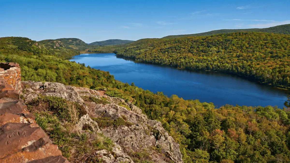
But the reason most people make the long drive out here is one view.
At the end of M-107, a short paved trail leads through ancient hemlocks to a boardwalk on the edge of a cliff. Step up to the rail, and the whole world opens up below you. A dark, still lake cradled in an unbroken sea of forest that rolls to the horizon in every direction. No roads, no buildings, nothing but trees. This is the Lake of the Clouds, and it is the most photographed spot in the entire U.P.
It is the kind of view a photo can never quite do justice. See it for yourself:
As anyone who has stood there will tell you, even the best footage undersells it. And it only gets louder in the fall, when the hardwoods explode into orange and red and the whole valley catches fire with color.
The Porkies are real wilderness, too, not a manicured park. Cell service mostly disappears once you are inside. Black bears roam the woods here in some of the highest numbers in Michigan, along with wolves and moose.
Beyond the famous overlook, there are more than 90 miles of trails, dozens of waterfalls along the Presque Isle River, and the Summit Peak tower with a 360-degree view. You can spend an afternoon or lose a week out here.
Here is something most people do not know. In the late 1930s, the Porcupine Mountains were nearly made a national park. World War II shelved the plan, so Michigan stepped in and protected the land as a state park instead, saving the old-growth from the saws.
Getting in just takes a Michigan Recreation Passport on your vehicle, and the Lake of the Clouds overlook itself is an easy, accessible walk that almost anyone can manage.
It belongs on the same short list as the U.P.’s other natural showstoppers, like the painted cliffs of Pictured Rocks.
And if you are chasing that big-water beauty, the crystal-clear Kitch-iti-kipi spring is worth the drive too.
For a place this wild and this beautiful, it stays surprisingly uncrowded. So point the car west, follow the road until it ends at that cliff, and see the U.P. the way it looked long before any of us got here.
Recommended Reads
The Soo Locks are the busiest in the world, and you can watch giant freighters for free
Forty years ago, Michigan brought moose back to the U.P. by dangling them from helicopters
This weekend you can fish, ride the trails, and hit every U.P. state park for free
Topics: Porcupine Mountains, Lake of the Clouds, Ontonagon County, state parks, old-growth forest, things to do, Lake Superior, Upper Peninsula, Yooper
Sources: Pure Michigan, the Michigan DNR, and the Upper Peninsula Travel & Recreation Association.
Keep exploring
More From Yooper Hub


Know a story we should cover?
Help Us Find What Matters Across the U.P.
Send us a local lead, community event, photo, or story idea. The best Yooper Hub stories often begin with a reader.
YOUR READING IS COUNTING
You are earning Yooper Points.
Your progress is saved in this browser. Finish the story to earn 10 points, then keep them with a free account.