Laughing Whitefish Falls pours 100 feet down a fan-shaped wall of rock in Alger County, and the walk in from the parking lot is half a mile through beech and maple. Most write-ups, Wikipedia’s included, call that wall a limestone escarpment. The Michigan Geological Survey studied it in 1958 and found sandstone nearly top to bottom, under a thin lid of harder dolomite. Nobody has told the waterfall, and it carries on regardless.
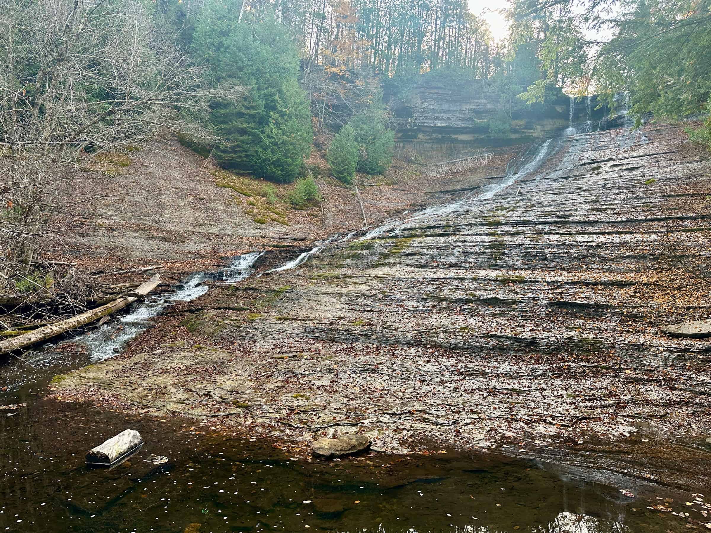
The state park around it covers 960 acres along the Laughing Whitefish River, which runs north into Lake Superior. It was established in 1946 and is run by the Michigan Department of Natural Resources. The falls sit about three miles north of M-94, up Sundell Road, and the whole trip from the lot is a mile round trip.

Sandstone wearing a hard hat
William Kenneth Hamblin’s 1958 survey of the Cambrian sandstones of northern Michigan used Laughing Whitefish Falls as its example of the waterfalls found all over Alger County. Except for a thin cap rock of the Au Train formation, he wrote, the entire exposed section is the Miner’s Castle member. The National Park Service describes that member as a poorly sorted quartz sandstone, the topmost layer of the Munising Formation at Pictured Rocks.
The Au Train on top is the tough part. Michigan State University geographer Randall Schaetzl describes it as Ordovician sandy dolomite sitting on softer Cambrian sandstone, and says the dolomite forms a caprock where waterfalls form. Wikipedia, limestone and all, credits the shape of the escarpment with drawing the water out into an unusual fan-shaped wall.
Hamblin also did some counting. He found 44 separate layers carrying ripple marks in the lower 50 feet of the outcrop, and noted those marks were noticeably lacking at other outcrops. One of his photographs from the falls shows a hammer laid on the rock with its handle pointing in the direction of the inferred current.

The name came first
Laughing Whitefish is also a 1965 novel by John D. Voelker, the former Michigan Supreme Court justice who wrote as Robert Traver. Its title character is Charlotte Kawbawgam, a Chippewa woman known as Laughing Whitefish. The book fictionalizes Kobogum v. Jackson Iron Co., an 1889 Michigan Supreme Court case over a share the company promised her father, Marji Gesick, for leading it to the Jackson Mine ore.
The falls had the name long before the book. The New York Public Library holds an A. G. Emery stereograph titled Laughing Whitefish Falls, 25 miles from Marquette, L.S., dated to about the 1860s with coverage running to about 1890. By our own calculation that is at least 75 years before the novel. We found no primary record of who named the river or why.
Stairs and a promotion
The upper platform, above the falls, needs no stairs. A wooden staircase drops 20 steps to the middle platform and 137 to the lower one, and all 137 are still there on the way back. It used to be a state scenic site, the name a 1979 state rule gave to 360 acres here, and it has since been upgraded to a full state park.
Sources: Michigan Department of Natural Resources; Michigan Department of Conservation, Geological Survey Division (Publication 51, 1958); National Park Service; Michigan State University; Michigan Administrative Code; New York Public Library; Michigan State University College of Law (Matthew L. M. Fletcher); Wikipedia.
Go See It
Laughing Whitefish Falls State Park
- Hours
- 8 a.m. to 10 p.m. daily, the DNR day-use hours for state parks
- Cost
- A Recreation Passport is required for vehicle entry. $15 for Michigan plates, added when you renew your registration. Out of state: $12 for the day or $42 for the year
- Season
- The road in is seasonal and unplowed in winter, with no turnaround. In winter the falls are a snowshoe or ungroomed ski trip
- Drive
- From Marquette: About 31 minutes and 26 miles (Google Maps route, read Sept. 26, 2026; allow more in bad weather)
From the Bridge: About 2 hours 26 minutes and 147 miles via US-2 W, with the Mackinac Bridge toll (Google Maps route, usual traffic, read Sept. 27, 2026) - Directions
- From M-94, turn north on Sundell Road and go 2 miles. Keep straight another quarter mile where the pavement turns to gravel. Turn right on Laughing Whitefish Falls Road at the park sign and go 0.4 miles to the lot.
- The walk
- Half a mile each way on a natural-surface trail through beech and maple.
- Decks
- Three observation platforms. A wooden staircase reaches the middle one 20 steps down and the lower one 137 steps down, so the best view costs you the climb back.
- At the lot
- Accessible vault toilet, charcoal grill and a hand pump for water.
- Phone
- 906-341-2355 (Michigan DNR).
- Winter
- Conditions change; call the DNR before a winter trip.
More worth reading


Sources, credits, and reporting details
Sources & accountability
How this story was reported
Editorial methodAggregation
Last verifiedSep. 26, 2026
Corrections statusNo material correction note is recorded on this article.
AI assistanceResearched and drafted with AI tools. Reviewed and approved by editor Keegan O’Brien.
Verification note: Sources read and checked Sept. 26, 2026.
Primary sources
-
Geology of the Precambrian, Jacobsville, and Munising Formations, Northern Michigan (The Cambrian Sandstones of Northern Michigan), Publication 51, Figure 59 — Michigan Department of Conservation, Geological Survey Division (Wm. Kenneth Hamblin)
Accessed Sep. 26, 2026.
"Laughing Whitefish Falls, Alger County, Michigan. An excellent example of the numerous waterfalls developed throughout Alger County, where the north-flowing streams across the cuesta developed on the resistant Au Train formation. Except for a thin cap rock of Au Train the entire exposed section is the Miner's Castle member."
-
The Cambrian Sandstones of Northern Michigan, Publication 51 — Michigan Department of Conservation, Geological Survey Division
Accessed Sep. 26, 2026.
Supports: Miner's Castle member is sandstone; Au Train is sandy dolomite (the 'harder dolomite' lid)
"consists of poorly sorted sandstone which is characteristically cross-bedded" (Miner's Castle member) / "a sequence of thin- to medium-bedded sandy dolomites and dolomitic sands" (Au Train formation)
-
Geologic Formations – Pictured Rocks National Lakeshore — National Park Service
Accessed Sep. 26, 2026.
"The Miners Castle Member overlies the Chapel Rock Member and is the topmost member of the Munising Formation." / "a light gray to white, poorly sorted silty-shaley quartz sandstone"
-
Waterfalls of Michigan — Michigan State University (Randall Schaetzl, Professor of Geography)
Accessed Sep. 26, 2026.
"Many of Michigan's waterfalls occur where hard Au Train dolomite overlies relatively softer Cambrian sandstones, such as in the Munising area. Here, the softer Chapel Rock and Miner's Castle sandstones lie under the harder, Ordovician-age sandy dolomite rocks. The dolomite forms a caprock, and waterfalls form." / "Laughing Whitefish Falls, Au Train Falls, and many others."
-
Geology of the Precambrian, Jacobsville, and Munising Formations, Northern Michigan, Publication 51 (ripple marks) — Michigan Department of Conservation, Geological Survey Division
Accessed Sep. 26, 2026.
Supports: 44 layers with ripple marks in the lower 50 feet; noticeably lacking at other outcrops
"Forty-four strata containing ripple marks were observed in the lower 50 feet of the outcrop at Laughing Whitefish Falls, but at other outcrops these structures are noticeably lacking."
-
Geology of the Precambrian, Jacobsville, and Munising Formations, Northern Michigan, Publication 51, Figure 66 — Michigan Department of Conservation, Geological Survey Division
Accessed Sep. 26, 2026.
Supports: Photo at the falls with a hammer handle pointing in the direction of the inferred current
"Small-scale trough cross-stratification in the Miner's Castle member, Laughing Whitefish Falls. Hammer handle points in the direction of inferred current flow."
-
Laughing Whitefish Falls State Park — Michigan Department of Natural Resources
Accessed Sep. 26, 2026.
Supports: Up Sundell Road; a mile round trip; half-mile trail to three observation platforms
"Three observation platforms can be reached via a half-mile hike through a beech-maple forest (1 mile round-trip)." / "From M-94, turn onto Sundell Road and continue north for 2 miles."
-
Laughing Whitefish: A Tale of Justice and Anishinaabe Custom (MSU Legal Studies Research Paper No. 06-16) — SSRN / Matthew L. M. Fletcher, Michigan State University College of Law
Accessed Sep. 26, 2026.
"Laughing Whitefish, a novel by Robert Traver, the pen name of former Michigan Supreme Court Justice John Voelker, is the fictionalized story of a case that reached the Michigan Supreme Court three times, culminating in Kobogum v. Jackson Iron Co., 43 N.W. 602 (Mich. 1889)." / "brought suit to recover under a note issued to her father, Marji Gesick, by the mining company in the 1840s. The company had promised a share in the company because he had led them to one of the largest iron ore deposits in the country, the famed Jackson Mine." / "upheld the claim"
-
File:Laughing Whitefish Falls, 25 miles from Marquette, L.S, by Emery, A. G.jpg (New York Public Library digital ID G90F415_006F) — New York Public Library, via Wikimedia Commons
Accessed Sep. 26, 2026.
Title: "Laughing Whitefish Falls, 25 miles from Marquette, L.S." / Artist: "Emery, A. G — Photographer" / Date: "Created: ca. 186-. Coverage: 1865?-1890?." / Credit: "This image is available from the New York Public Library's Digital Library under the digital ID G90F415_006F"
-
Laughing Whitefish Falls State Park — Michigan Department of Natural Resources
Accessed Sep. 26, 2026.
Supports: Upper platform above the falls, no stairs; wooden staircase 20 steps to middle, 137 to lower
"The upper-level observation platform offers views from above the falls and does not have any stairs leading to it." / "A wooden staircase leads to a middle-level observation platform (20 stairs from the top) and continues to a lower-level observation platform (137 stairs from the top)."
-
Mich. Admin. Code R. 322.2.2 – Laughing Whitefish Falls scenic site — Michigan Administrative Code (via Cornell Legal Information Institute)
Accessed Sep. 26, 2026.
"The following described area is proposed for rededication pursuant to Act No. 241 of the Public Acts of 1972 … as a natural area under the designation of the Laughing Whitefish Falls scenic site: W1/2 and NW1/4 of NE1/4 Sec. 16, T46N, R22W, Rock River township, Alger county. Total 360 acres." / History: "1979 AC"
-
Laughing Whitefish Falls State Park — Michigan Department of Natural Resources
Accessed Sep. 26, 2026.
Supports: Go See It / Where: GPS 46.384541, -87.067191; Laughing Whitefish Falls Road off Sundell Road
"46.384541,-87.067191" / "Turn right onto Laughing Whitefish Falls Road (indicated by park signage)"
-
Laughing Whitefish Falls State Park — Michigan Department of Natural Resources
Accessed Sep. 26, 2026.
Supports: Go See It / Road: directions and muddy dirt road
"From M-94, turn onto Sundell Road and continue north for 2 miles. Continue straight another quarter mile as the paved road transitions to an unpaved road. Turn right onto Laughing Whitefish Falls Road (indicated by park signage) and continue .4 miles to the parking area." / "The dirt road leading to the park can be muddy at times."
-
Rules and regulations (state parks) — Michigan Department of Natural Resources
Accessed Sep. 26, 2026.
Supports: Go See It / Hours: 8 a.m. to 10 p.m. daily
"State parks and recreation area day-use hours are open 8 a.m. to 10 p.m. daily."
-
Laughing Whitefish Falls State Park — Michigan Department of Natural Resources
Accessed Sep. 26, 2026.
Supports: Go See It / Cost: Recreation Passport required for vehicle entry
"A Recreation Passport (park pass) is required for vehicle entry into all state park and forest campgrounds."
-
Recreation Passport — Michigan Department of Natural Resources
Accessed Sep. 26, 2026.
Supports: Go See It / Cost: $15 vehicle, $7 motorcycle at plate renewal; nonresident $12 daily, $42 annual
"Vehicles $15" / "Motorcycles $7" (at license plate registration renewal through the Secretary of State) / Nonresident: "Annual $42" / "Daily $12"
-
Laughing Whitefish Falls State Park — Michigan Department of Natural Resources
Accessed Sep. 26, 2026.
"During the winter, the park is only accessible via snowshoe or ungroomed cross-country ski trails. The road leading into the park is seasonal and unplowed with no turn-around."
-
Laughing Whitefish Falls State Park — Michigan Department of Natural Resources
Accessed Sep. 26, 2026.
"Three observation platforms can be reached via a half-mile hike through a beech-maple forest (1 mile round-trip)." / "(20 stairs from the top)" / "(137 stairs from the top)" / "a 1.9-mile spur trail"
-
Laughing Whitefish Falls State Park — Michigan Department of Natural Resources
Accessed Sep. 26, 2026.
Supports: Go See It / Facilities: grill and hand pump near parking; phone
"There is a charcoal grill and hand pump for water near the parking area." / "Phone: 906-341-2355"
-
Laughing Whitefish Falls State Park Map (updated 08/03/2021) — Michigan Department of Natural Resources
Published Aug. 3, 2021. Accessed Sep. 26, 2026.
Supports: Go See It / Facilities: vault toilet
Map legend: "Vault Toilet"; "Observation Platform"; "Updated: 08/03/2021"
-
Google Maps driving directions from Marquette — Google Maps
Accessed Sep. 26, 2026.
Read live in Chrome Sep 26, 2026 (Saturday): "Driving 31 min, 25.8 miles via US-41 S".

Additional reporting
-
Laughing Whitefish Falls State Park — Wikipedia
Accessed Sep. 26, 2026.
Supports: Laughing Whitefish Falls is a 100-foot fan-shaped cascade
"Its main scenic feature is Laughing Whitefish Falls, a 100-foot fan-shaped cascade located in the southern part of the site, in Rock River Township, eight miles (13 km) south of Lake Superior and three miles north of M-94."
-
Laughing Whitefish Falls — gowaterfalling.com
Accessed Sep. 26, 2026.
Supports: 100 feet (second source for height)
Height listed as "100" feet
-
Laughing Whitefish Falls State Park — Wikipedia
Accessed Sep. 26, 2026.
Supports: Alger County; half-mile walk through beech-maple forest
"It can be reached by a half-mile hike through beech-maple forest." / "in far western Alger County, Michigan"
-
Laughing Whitefish Falls State Park — Wikipedia
Accessed Sep. 26, 2026.
Supports: WRONG CLAIM corrected: Wikipedia calls the wall a limestone escarpment
"Laughing Whitefish Falls is formed by an abrupt limestone escarpment of the Laughing Whitefish River, which flows northward into Lake Superior."
-
Laughing Whitefish Falls State Park — Wikipedia
Accessed Sep. 26, 2026.
Supports: The escarpment's shape draws the water out into an unusual fan-shaped wall
"The escarpment is shaped so as to draw out the cascade into an unusual fan-shaped wall of water."
-
Laughing Whitefish Falls State Park — Wikipedia
Accessed Sep. 26, 2026.
Supports: 960 acres along the Laughing Whitefish River; river runs north into Lake Superior
"Laughing Whitefish Falls State Park is a public recreation area protecting 960 acres (390 ha) along the Laughing Whitefish River in Onota Township and Rock River Township" / "which flows northward into Lake Superior"
-
Laughing Whitefish Falls State Park (infobox) — Wikipedia
Accessed Sep. 26, 2026.
Supports: Established 1946; administered by Michigan DNR
"Established: 1946" / "Administrator: Michigan Department of Natural Resources"
-
Laughing Whitefish Falls State Park — Wikipedia
Accessed Sep. 26, 2026.
Supports: About three miles north of M-94
"three miles north of M-94"
-
Laughing Whitefish — Wikipedia
Accessed Sep. 26, 2026.
Supports: 1965 novel by John D. Voelker writing as Robert Traver
"Laughing Whitefish is a 1965 historical novel by Justice John D. Voelker, writing under the pen name "Robert Traver.""
-
Laughing Whitefish — Wikipedia
Accessed Sep. 26, 2026.
Supports: Title character Charlotte Kawbawgam, a Chippewa also known as Laughing Whitefish
"Charlotte Kawbawgam, a Chippewa also known as Laughing Whitefish who is the youthful orphaned daughter of a traditional polygamous Chippewa marriage"
-
Laughing Whitefish (book page) — Michigan State University Press
Accessed Sep. 26, 2026.
Supports: Charlotte Kawbawgam known as Laughing Whitefish (second source)
Book description: Charlotte Kawbawgam "(known as Laughing Whitefish)"
-
CALCULATED — YooperHub
Accessed Sep. 26, 2026.
Supports: At least 75 years between the stereograph and the novel
CALCULATED: NYPL coverage end 1890 (latest possible date of the card) to 1965 novel = 75 years.
-
List of Michigan state parks — Wikipedia
Accessed Sep. 26, 2026.
Supports: Formerly a state scenic site, upgraded to full state park status
"Laughing Whitefish Falls State Park was formerly a State Scenic Site, but has since been upgraded to full state park status."
-
Laughing Whitefish Falls State Park — Wikipedia
Accessed Sep. 26, 2026.
Supports: Go See It / Where: Rock River Township, Alger County
"in Rock River Township" / "in far western Alger County, Michigan"
Photo and media credits
-
54091826624_fa1fe29e39_o.jpg (featured, media 3040) — Flickr / Seclusive Nature
Featured image record. Published Oct. 22, 2024. Accessed Sep. 26, 2026. CC BY-SA 4.0.
Supports: Image credit and licence.
Licence read off the source page Sep 26, 2026; 4032×3024 original, uploaded as a downscale.
-
54092642987_2bd7cdf90c_o.jpg (media 3041) — Flickr / Seclusive Nature
Published Oct. 22, 2024. Accessed Sep. 26, 2026. CC BY-SA 4.0.
Supports: Image credit and licence.
Licence read off the source page Sep 26, 2026; 1920×1080 original, uploaded as a downscale.
-
Laughing_Whitefish_Falls-_25_miles_from_Marquette-_L.S-_by_Emery-_A._G.jpg (media 3042) — Wikimedia Commons / A. G. Emery (New York Public Library)
Accessed Sep. 26, 2026. Public domain.
Supports: Image credit and licence.
Licence read off the source page Sep 26, 2026; 2737×1395 original, uploaded as a downscale.