The English name on the map is Point Iroquois. The older name for the same ground is Nadouenigoning, from the Ojibwe words for Iroquois and for bone.
It means the place of Iroquois bones, and it is not a metaphor. Something happened on that bluff in 1662, roughly two centuries before anyone put a lighthouse on it.

What happened in 1662
The Haudenosaunee — the Iroquois — were pushing west, sending war parties far from their homeland to take control of the trade routes running east out of the Great Lakes. One of those parties came up to the foot of Whitefish Bay and made camp near the point.
The Ojibwe found them. According to accounts passed down for more than three hundred years, they watched the camp without being seen, waited through the night, and beached their canoes quietly as the Iroquois were falling asleep near dawn. The attack that followed killed nearly the entire party.
One version of the story comes from Ozhaguscodaywayquay, an Ojibwe woman whose account was written down in 1827. In her telling, two Iroquois were deliberately left alive, handed a canoe, and sent home to tell their people what had happened and never to come into Ojibwe country again.
The westward push stopped there. Whatever else is uncertain about the details, that outcome is why the name stuck.
The lighthouse came much later
In January 1853 the Michigan legislature asked its congressional delegation to push for thirteen new lighthouses in the state. One of them was to go at Point Iroquois. Congress put up $5,000, a contract was signed in 1854, and a stone tower with a wooden stairway went up on the bluff in the mid-1850s. Charles Caldwell, who had been an assistant keeper at Whitefish Point, took the job first.
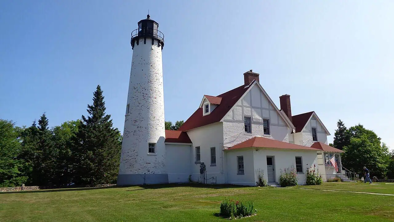
That original station did not last. In 1870 the wooden tower and dwelling were replaced with the brick buildings that are still standing today — a 65-foot tower carrying a fourth-order Fresnel lens, its light sitting 72 feet above the water.

Why it mattered so much
Point Iroquois marks the line where Whitefish Bay ends and the St. Marys River begins. Every freighter moving between Lake Superior and the rest of the Great Lakes has to thread that gap, between the sandbars and shoals off the point and the rocky reefs at Gros Cap on the Canadian shore.
As traffic through the Soo Locks grew, the light got more important, not less. It is also the worst possible stretch to get wrong: this is the same corner of Lake Superior where the weather does what it did to the 1913 storm fleet.
The keepers stayed until the early 1960s, when an automatic light in the channel off Gros Cap made the station unnecessary. It was listed on the National Register of Historic Places in 1975.
Who keeps it now
The site sits inside the Hiawatha National Forest and operates as a museum. The Bay Mills/Brimley Historical Research Society leases it and has driven the restoration, with help from HistoriCorps, YouthWork, and a long list of volunteers.
What makes this one different from most restored lighthouses is that the exhibits do not stop at maritime history. The museum works in partnership with the Bay Mills Indian Community, and the displays cover Anishinaabe heritage alongside the keeper’s quarters and the shipping story. The place is interpreted by the descendants of the people who named it.
Climbing the tower
Point Iroquois is near Brimley in Chippewa County, west of Sault Ste. Marie along the Whitefish Bay National Forest Scenic Byway. The season runs roughly late May through mid-October, and admission is free.
You can climb 72 steps to the top of the tower for the view down the bay, walk through the restored keeper’s quarters, and take an accessible boardwalk out to the shoreline. If you are collecting these, we have a wider roundup of U.P. lighthouses worth the drive.
More worth reading


Yooper Hub community
The conversation
Know something this story missed? Corrections and additions get read by an editor and folded into the article, with credit.
Real neighbors, real names. A Yooper Hub editor reads your first comment before it appears; after that you’re a known neighbor and your comments post right away. No account required. Community guidelines
Nothing here yet. A sentence is plenty: a correction, a name, or what you remember about this place.
Sources, credits, and reporting details
Sources & accountability
How this story was reported
Editorial methodArchival synthesis
Last verifiedAug. 15, 2026
Corrections statusNo material correction note is recorded on this article.
AI assistanceResearched and drafted with AI tools. Reviewed and approved by editor Keegan O’Brien. Tool: Claude Opus 5.
Verification note: Ledger reconstructed 2026-08-15 from the Forest Service's announcement of Bay Mills Indian Community management, the state historical marker, and Wikipedia as a pointer to the National Register record. Tour hours and the museum season should be checked with Bay Mills before promoting the piece.
Primary sources
-
Bay Mills Indian Community to manage Point Iroquois Lighthouse, museum — U.S. Forest Service
Accessed Aug. 15, 2026.
-
Point Iroquois Light Station historical marker — Whitefish Bay Scenic Byway and Hiawatha National Forest, via HMdb
Accessed Aug. 15, 2026.
Additional reporting
-
Point Iroquois Light — Wikipedia contributors
Accessed Aug. 15, 2026.
Supports: 65-foot tower; National Register listing 1975; the Ojibwe name and its translation.
Pointer.
Photo and media credits
-
Point Iroquois Lighthouse (featured image) — Notorious4life, via Wikimedia Commons
Featured image record. Accessed Aug. 4, 2026. CC0.
Creator and license from the attachment caption. Attachment 2086, 1280×720.