The orange, black and white running down the Pictured Rocks cliffs is mineral stain, and it is still arriving.
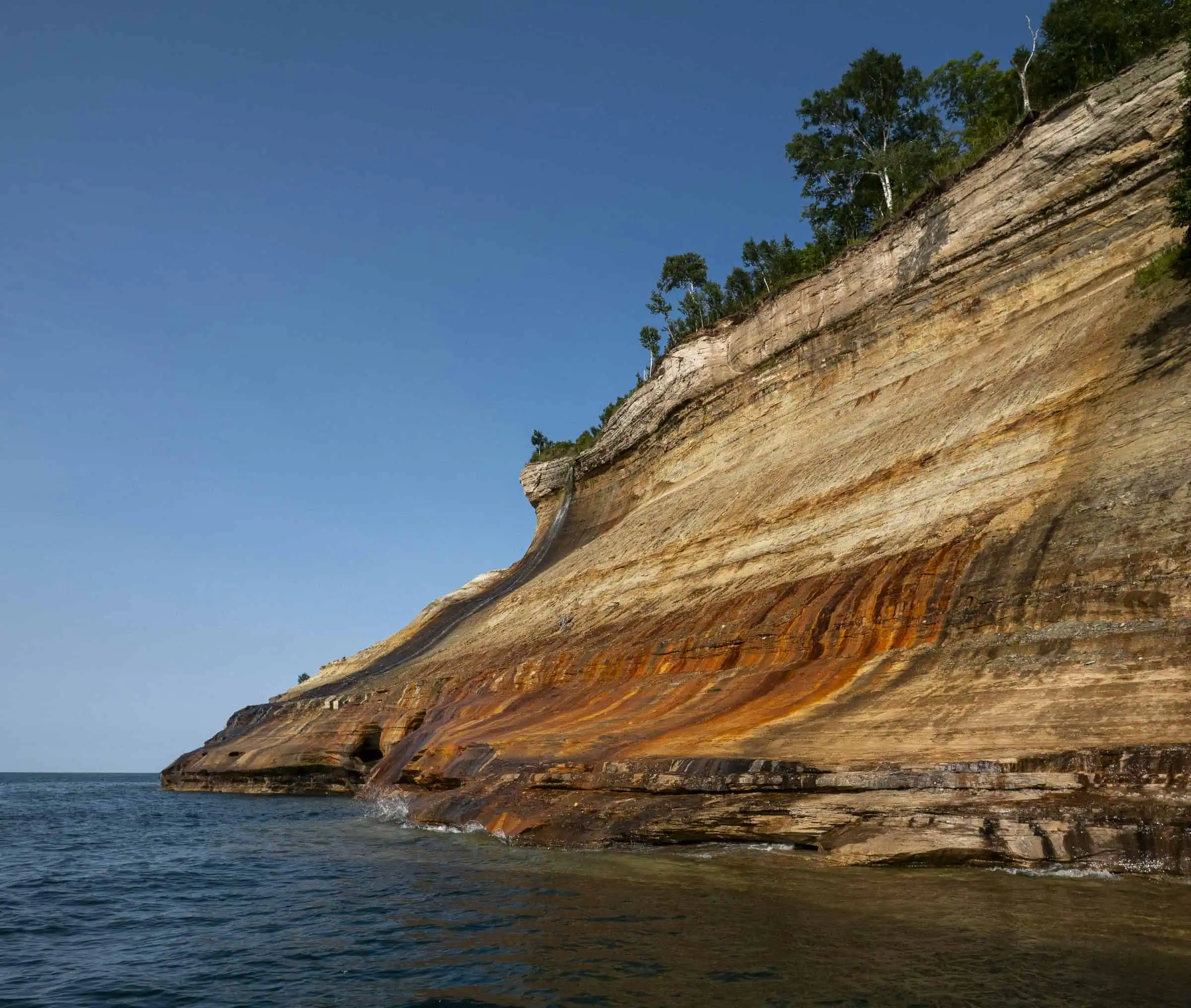
Stunning colors occur when groundwater oozes out of cracks and trickles down the rock face.
National Park Service, Pictured Rocks geologic formations
Groundwater works through the porous sandstone, seeps out of cracks in the face, and leaves metal behind as it trickles toward Lake Superior. The rock underneath is plain sandstone.
Each color is a different metal
Iron leaves the orange. Manganese leaves the black. The park’s ranger video credits limonite with the white. Copper leaves blues and greens, and the Park Service notes those are “not as abundant as the other colors,” which is why you can look at a mile of cliff and never find any.
The colors move with the water. A wall that has been wet all spring reads differently from the same wall in a dry August, and the Park Service says “late afternoon or early evening sunlight brings out the richest colors.”

One thing most coverage gets wrong
Brown gets handed to the wrong mineral almost everywhere, and the Park Service’s own page is part of the reason. One sentence there lists “manganese (brown and black).” A second sentence on the same page says “the orange and brown staining is caused by iron.” A ranger’s geology video for the park says the same as the second sentence.
Two sources to one. Brown is iron.
How big it actually is
The cliffs stretch “about 15 miles along the lake from Sand Point on the west to just after Spray Falls on the east,” standing 50 to 200 feet above the water. That is the cliff section, not the whole park. Pictured Rocks runs considerably further along the shoreline, and the colored wall is its western end. A lot of writing about the park quietly swaps one figure for the other.

Seeing them
Most of those 15 miles have no road near them. The Park Service puts it plainly: “The best view of the cliffs is from the water.” A Park Service-authorized concessionaire runs a non-stop cliff tour from mid-May through mid-October.
From land, the 10-mile loop in the Chapel Basin “provides the best views from land.” If ten miles is more than you came for, Miners Castle has a lower overlook that “provides a view of the cliffs in the distance, looking eastward.”
One thing to know before you point a GPS at it: the Park Service asks you to search for the Munising Falls Visitor Center or its street address rather than the park name, which will drop you somewhere unhelpful. The Munising Falls trail itself has been closed since storm damage in April 2025. The Park Service awarded a repair contract on Sept. 3 and expects the work done by the end of 2027.
Go See It
- Where: 1505 Sand Point Road, Munising, MI. Navigate to “Munising Falls Visitor Center” or that address, not to the park name.
- Drive: east from Marquette on M-28.
- Hours: open year-round, 24 hours a day. Many roads close with snow. Unplowed park roads are snowmobile-only from Dec. 1 to March 31.
- Cost: a standard pass is $15 to $25 and covers seven days; an annual park pass is $45. The park does not take cash, only cards.
- Boat season: mid-May through mid-October.
- Best land view: the 10-mile Chapel Basin loop. Shortest: the Miners Castle lower overlook.
More worth reading


Sources, credits, and reporting details
Sources & accountability
How this story was reported
Editorial methodAggregation
Last verifiedSep. 26, 2026
Corrections statusNo material correction note is recorded on this article.
AI assistanceResearched and drafted with AI tools. Reviewed and approved by editor Keegan O’Brien.
Verification note: Sources re-read Sept. 26, 2026. The line about when the colors show best now quotes the Park Service page directly.
Primary sources
-
Geologic Formations — National Park Service
Accessed Sep. 26, 2026.
Supports: Groundwater oozes out of cracks and leaves the color (quoted in the article).
"Stunning colors occur when groundwater oozes out of cracks and trickles down the rock face."
-
Geologic Formations — National Park Service
Accessed Sep. 26, 2026.
"The orange and brown staining is caused by iron" / "black stains are caused by manganese" / "white stains are caused by limonite" / blues and greens caused by copper, "not as abundant as the other colors"
-
Pictured Rocks Cliffs — National Park Service
Accessed Sep. 26, 2026.
Supports: About 15 miles, Sand Point to just after Spray Falls; 50 to 200 feet above the lake.
"These sandstone cliffs stretch for about 15 miles along the lake from Sand Point on the west to just after Spray Falls on the east." / "tower 50 to 200 feet above Lake Superior"
-
Pictured Rocks Cliffs — National Park Service
Accessed Sep. 26, 2026.
"The best view of the cliffs is from the water." / "non-stop boat tour of the Pictured Rocks cliffs from mid-May through mid-October" / "The 10-mile loop hiking trail in the Chapel Basin provides the best views from land." / "Miners Castle provides a view of the cliffs in the distance, looking eastward from the lower overlook."
-
Directions and Transportation — National Park Service
Accessed Sep. 26, 2026.
Supports: Navigate to Munising Falls Visitor Center or 1505 Sand Point Road, not the park name.
"Using 'Pictured Rocks National Lakeshore' will NOT bring you to a visitor center!" … "'Munising Falls Visitor Center' or '1505 Sand Point Road, Munising MI'"
-
Munising Falls Trail Construction Contract Awarded — National Park Service
Published Sep. 3, 2026. Accessed Sep. 26, 2026.
Supports: Trail closed since April 2025 storm; contract awarded Sept. 3; completion expected end of 2027.
"A 75-foot section of the Munising Falls Trail was destroyed during a heavy rainstorm in April of 2025" / "expected to be completed by the end of 2027"
-
Operating Hours & Seasons — National Park Service
Accessed Sep. 26, 2026.
Supports: Open year-round, 24 hours; many roads close with snow.
"Pictured Rocks National Lakeshore is open year-round, 24 hours a day, though many roads are closed by snow in the winter."
-
Winter Road Closures — National Park Service
Accessed Sep. 26, 2026.
Supports: Unplowed roads snowmobile-only Dec. 1 to March 31.
"December 1st – March 31st, these unplowed roads are considered snowmobile trails and are CLOSED to ALL vehicles except snowmobiles."
-
Fees & Passes — National Park Service
Accessed Sep. 26, 2026.
Supports: $15 to $25 for seven days; $45 annual; no cash.
"Per Person $15.00" / "Private Vehicle $25.00 (7 days)" / "Annual Entrance – Park $45.00" / "This park does not accept cash."
Additional reporting
-
Pictured Rocks Cliffs — National Park Service
Accessed Sep. 26, 2026.
Supports: The contradicting NPS sentence: "manganese (brown and black)".
"Iron (red and orange), copper (blue and green), manganese (brown and black), and limonite (white) are among the most common color-producing minerals."
-
Geologic Formations — National Park Service
Accessed Sep. 26, 2026.
Supports: Late afternoon or early evening sunlight brings out the richest colors.
"Late afternoon or early evening sunlight brings out the richest colors."
Photo and media credits
-
Multi-colored cliffs of Pictured Rocks National Lakeshore (featured, media 2924) — National Park Service (NPS Photo)
Featured image record. Accessed Sep. 26, 2026. Public domain (NPS).
Supports: Featured image.
Original nps.gov/piro/learn/nature/images/P1052460-2.jpg, 4020×3404, captioned by NPS on the Geologic Formations page. Upload 2400×2032 matches the aspect exactly (checked Sep 26).
-
Mineral stains at Pictured Rocks National Lakeshore (media 2925) — NPGallery, NPS
Accessed Sep. 26, 2026. Public domain: Full Granting Rights.
Supports: Body image.
NPGallery constraints: "Public domain:Full Granting Rights".
-
Pictured Rocks Cliffs (media 2926) — NPGallery, H. Bradburn / NPS
Published May. 15, 2024. Accessed Sep. 26, 2026. Public domain: Full Granting Rights.
Supports: Body image, credited H. Bradburn / NPS.
NPGallery constraints: "Public domain:Full Granting Rights".