Five named waterfalls sit on about two miles of the Black River north of Bessemer, and the road that reaches them ends at a harbor on Lake Superior. The U.S. Forest Service lists them from the top down: Conglomerate Falls farthest upstream, then Potawatomi, Gorge, Sandstone and Rainbow. Each one has its own signed trail off County Road 513, the Black River National Scenic Byway, in the Ottawa National Forest’s Bessemer Ranger District.
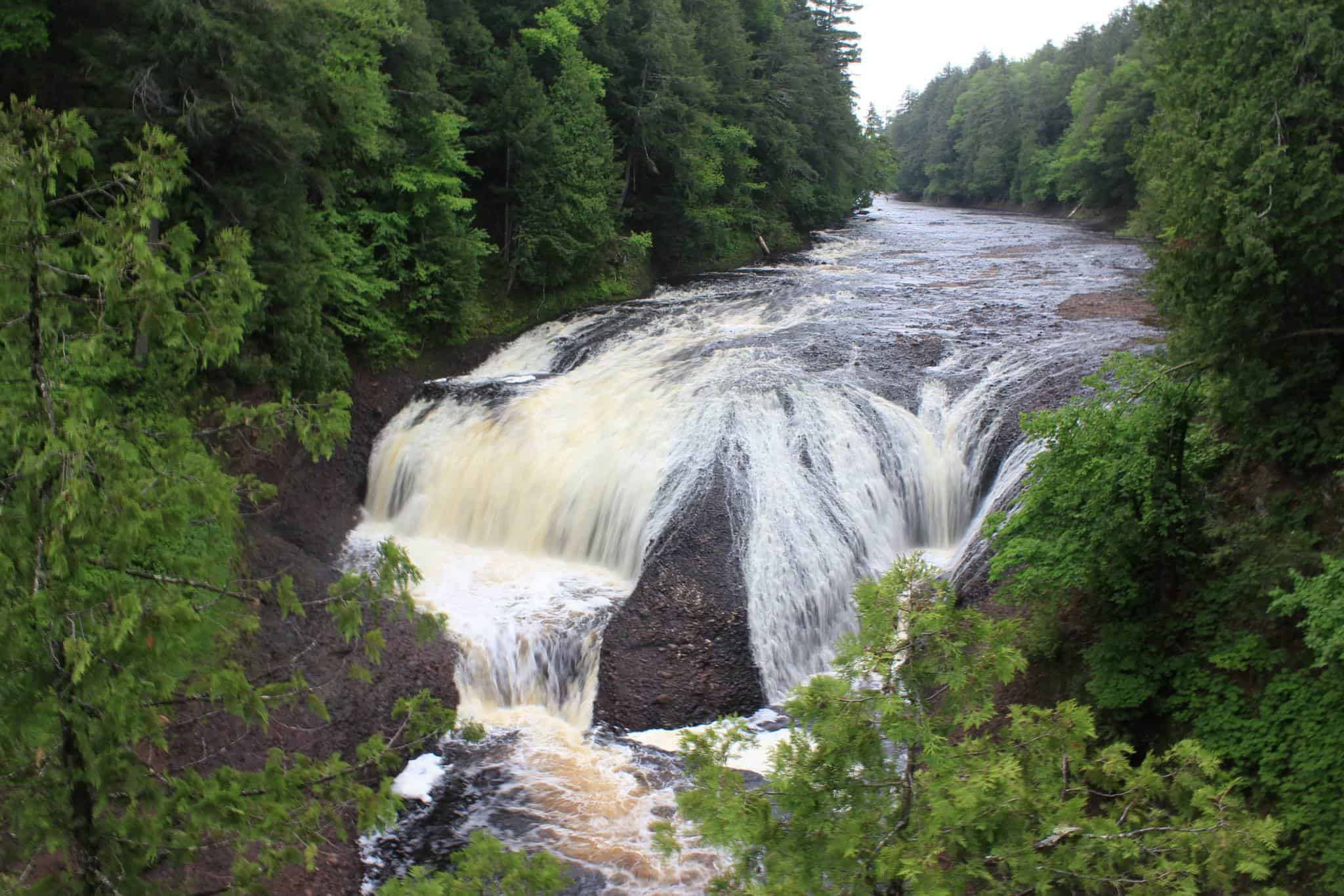
The drops are bigger than the walks. The Forest Service puts Conglomerate and Rainbow at 40 feet each and Potawatomi at 30 feet across a 130 foot wide crest. Gorge Falls is the narrow one, 29 feet wide with a 24 foot drop, even though the Ironwood Area Chamber of Commerce and the Western U.P. visitors bureau both list it at 34 feet. The Forest Service, which manages the falls, says 24.

One road, five trailheads
The byway starts where County Road 513 meets County Road 204, also called Airport Road, and runs north for 11 miles to the harbor, according to Recreation.gov. It was dedicated as a National Forest Scenic Byway on September 19, 1992. The Forest Service’s own directions put the Conglomerate lot about 8.5 miles up CR 513 from Powderhorn Road and the Rainbow lot about 10.5. By our own calculation that is roughly two miles of road for all five falls.
Conglomerate is the longest walk at three quarters of a mile, and the river splits there around an island of conglomerate rock, which is where the name comes from. Potawatomi and Gorge share one parking lot, and an asphalt path from the Gorge end reaches an accessible viewing platform over Potawatomi. Sandstone is a steep quarter mile of steps, and the Forest Service concedes it comes up short on size but says the rock hollows carved by the river make the trip worth it. Rainbow is a half mile to a stairway and an observation platform, named for the mist that sometimes throws a rainbow when the sun hits it right.

Sandstone Falls is closed this fall
Sandstone Falls is closed for construction, according to its Forest Service page. The Ottawa National Forest started work on May 18 to repair and replace viewing platforms, stairways and trail structures along the river, beginning with about 210 linear feet of aging timber steps and railing at Sandstone. The May notice said the project would close portions of the Potawatomi, Gorge and Rainbow trails later in the summer, and construction is expected to continue through fall 2027. Conglomerate was listed open, with a warning to watch the tread and stairs.
Where the road runs out
County Road 513 ends at Black River Harbor, which Recreation.gov calls one of only two harbors within the National Forest System. There is a boat launch, a Lake Superior beach, a pavilion built by the Civilian Conservation Corps and a wooden suspension bridge across the river. Cross it and the North Country Trail runs three quarters of a mile to the east side of Rainbow Falls, which the Forest Service says is the better angle for a photographer. In September, chinook and coho salmon run upstream to the falls.
Go See It
Where: Black River National Scenic Byway (County Road 513), from County Road 204 north to Black River Harbor, about 15 miles north of Bessemer. Harbor GPS: 46.66416, -90.05191.
Hours: Waterfall trailheads are day use only, sunrise to sunset. The harbor recreation area is open 24 hours.
Cost: No fee at the Conglomerate, Potawatomi and Gorge, or Sandstone trailheads. Black River Harbor day use and boat launch is $5 per vehicle per day or $30 per vehicle per season, with day use fees in place until October 15, 2026.
Season: Sandstone Falls is closed for construction. Portions of the Potawatomi, Gorge and Rainbow trails may close while work runs through fall 2027, so call the Bessemer Ranger District at 906-852-3500 ext. 0 before you go. The day use area and waterfall trailheads are open year-round.
Drive: About 2 hours 45 minutes and 154 miles from Marquette to Black River Harbor by US-41 and M-28, per Google Maps (read Sept. 26, 2026). Gogebic County is on Central time.
Trails: Conglomerate 3/4 mile. Potawatomi and Gorge short, with a series of stairways. Sandstone 1/4 mile, short but steep. Rainbow 1/2 mile from CR 513, or 3/4 mile from the harbor over the suspension bridge.
Facilities: Toilets and picnic sites at the Gorge Falls lot. Accessible trail, restroom and viewing platform at Potawatomi. No potable water at the waterfall sites.
Sources: USDA Forest Service, Ottawa National Forest; Recreation.gov; Ironwood Area Chamber of Commerce; Western U.P. Convention & Visitor Bureau; K-Bear 102; WNMU-FM.
More worth reading


Sources, credits, and reporting details
Sources & accountability
How this story was reported
Editorial methodAggregation
Last verifiedSep. 26, 2026
Corrections statusNo material correction note is recorded on this article.
AI assistanceResearched and drafted with AI tools. Reviewed and approved by editor Keegan O’Brien.
Verification note: Sources read and checked Sept. 26, 2026.
Primary sources
-
Black River Harbor Area (Wildflower Viewing Areas) — USDA Forest Service
Accessed Sep. 26, 2026.
"Conglomerate Falls is the farthest upstream, with Potawatomi, Gorge, Sandstone, and Rainbow spread out over about two miles below."
-
Black River Harbor Area (Wildflower Viewing Areas) — USDA Forest Service
Accessed Sep. 26, 2026.
Supports: North of Bessemer; Ottawa National Forest, Bessemer Ranger District
"About 15 miles north of Bessemer, Michigan, the Black River flows through eastern hemlock and northern hardwood forests" / "U.S. Forest Service, Ottawa National Forest, Bessemer Ranger District"
-
Black River Harbor Area (Wildflower Viewing Areas) — USDA Forest Service
Accessed Sep. 26, 2026.
Supports: Each falls has its own trail off County Road 513, the Black River National Scenic Byway
"from trailheads along the Black River National Scenic Byway (County Road 513)" / "trails into five distinct waterfall-viewing areas"
-
Recreation Site – Black River Harbor Recreation Area — USDA Forest Service, Ottawa National Forest
Accessed Sep. 26, 2026.
Supports: The road reaching the falls ends at a harbor on Lake Superior
"The River has a series of scenic waterfalls as it drops in elevation to meet Lake Superior."
-
Recreation Site – Conglomerate Waterfalls — USDA Forest Service, Ottawa National Forest
Accessed Sep. 26, 2026.
"the river seperates into two sections, falling 40-feet around an island of conglomerate rock, which gives the falls its name"
-
Recreation Site – Rainbow Falls — USDA Forest Service, Ottawa National Forest
Accessed Sep. 26, 2026.
Supports: Rainbow Falls drops 40 feet; named for the mist that sometimes throws a rainbow
"The falling water (40 feet) creates a mist, and sometimes with the right angle of sunlight, produces a rainbow effect, which gives the falls its name."
-
Recreation Site – Potawatomi and Gorge Waterfalls — USDA Forest Service, Ottawa National Forest
Accessed Sep. 26, 2026.
Supports: Potawatomi 30 foot drop, 130 foot wide; Gorge 29 feet wide, 24 foot drop (the correction)
"Gorge Falls has a 29 foot width and a 24 foot drop. Potawatomi Falls has a 130 foot width and a 30 foot drop."
-
Black River Harbor Area (Wildflower Viewing Areas) — USDA Forest Service
Accessed Sep. 26, 2026.
Supports: The Forest Service manages the falls
"U.S. Forest Service, Ottawa National Forest, Bessemer Ranger District" (listed as the managing agency for the Black River Harbor Area)
-
Black River Scenic Byway — Recreation.gov
Accessed Sep. 26, 2026.
Supports: Byway starts at CR 513 and CR 204 (Airport Road), runs north 11 miles to the harbor
"the Black River Harbor National Scenic Byway begins on County Road 513 at its intersection with County Road 204 (Airport Road) and continues north for 11 miles to Black River Harbor."
-
Black River Scenic Byway — Recreation.gov
Accessed Sep. 26, 2026.
Supports: Dedicated as a National Forest Scenic Byway on September 19, 1992
"On September 19, 1992, Highway 513, which follows this section of the Black River, was officially dedicated as a National Forest Scenic Byway"
-
Recreation Site – Conglomerate Waterfalls — USDA Forest Service, Ottawa National Forest
Accessed Sep. 26, 2026.
Supports: Conglomerate lot about 8.5 miles up CR 513 from Powderhorn Road
"turn left onto CR 513 and travel approximately 8 1/2 miles to the Conglomerate Falls parking lot on FR 108."
-
Recreation Site – Rainbow Falls — USDA Forest Service, Ottawa National Forest
Accessed Sep. 26, 2026.
Supports: Rainbow lot about 10.5 miles up CR 513
"turn left onto CR 513 and travel approximately 10 1/2 miles to the Rainbow Falls parking area on FR 118."
-
CALCULATED — YooperHub
Accessed Sep. 26, 2026.
Supports: By our own calculation, roughly two miles of road for all five falls
CALCULATED: 10.5 miles (Rainbow lot) minus 8.5 miles (Conglomerate lot) = 2 miles along CR 513, from the USFS directions quoted in the two rows above.
-
Recreation Site – Conglomerate Waterfalls — USDA Forest Service, Ottawa National Forest
Accessed Sep. 26, 2026.
Supports: Conglomerate is three quarters of a mile
"these waterfalls can be accessed by a 3/4 mile hiking trail from a paved parking lot."
-
Recreation Site – Potawatomi and Gorge Waterfalls — USDA Forest Service, Ottawa National Forest
Accessed Sep. 26, 2026.
"An asphalt surface trail connects the parking area at Gorge Falls to the accessible viewing platform overlooking Potawatomi Falls."
-
Recreation Site – Sandstone Falls — USDA Forest Service, Ottawa National Forest
Accessed Sep. 26, 2026.
Supports: Sandstone is a steep quarter mile of steps; not a large falls but the rock hollows are worth it
"the 1/4 mile trail to Sandstone Falls is short but steep, with a series of steps" / "Although Sandstone Falls is not a large falls, the area is well worth visiting because of its varied rock formations and hollows carved out of sandstone and conglomerate rock"
-
Recreation Site – Rainbow Falls — USDA Forest Service, Ottawa National Forest
Accessed Sep. 26, 2026.
Supports: Rainbow is a half mile to a stairway and an observation platform
"A 1/2 mile hiking trail will take you from a paved parking lot to a stairway dropping down to an observation platform overlooking the scenic Black River and Rainbow Falls."
-
Recreation Site – Sandstone Falls — USDA Forest Service, Ottawa National Forest
Accessed Sep. 26, 2026.
Supports: Sandstone Falls is closed for construction (page last updated May 18, 2026)
Operational Hours: "Closed for construction"
-
Black River Waterfall Platforms and Trails Undergoing Major Repairs — USDA Forest Service, Ottawa National Forest
Published May. 15, 2026. Accessed Sep. 26, 2026.
Supports: Work started May 18 to repair and replace platforms, stairways and trail structures
"The Ottawa National Forest will begin a major effort to repair and replace waterfall viewing platforms, stairways and trail structures along the Black River corridor beginning Monday, May 18."
-
Black River Waterfall Platforms and Trails Undergoing Major Repairs — USDA Forest Service, Ottawa National Forest
Published May. 15, 2026. Accessed Sep. 26, 2026.
Supports: About 210 linear feet of aging timber steps and railing at Sandstone
"Remove about 210 linear feet of aging timber steps and railing."
-
Black River Waterfall Platforms and Trails Undergoing Major Repairs — USDA Forest Service, Ottawa National Forest
Published May. 15, 2026. Accessed Sep. 26, 2026.
Supports: May notice: portions of the Potawatomi, Gorge and Rainbow trails to close later in the summer
"Potawatomi Falls | Open with some platform closures | Construction project will close portions of the trail later this summer." (same note for Gorge Falls and Rainbow Falls)
-
Black River Waterfall Platforms and Trails Undergoing Major Repairs — USDA Forest Service, Ottawa National Forest
Published May. 15, 2026. Accessed Sep. 26, 2026.
Supports: Construction expected to continue through fall 2027
"Construction is expected to continue through fall 2027."
-
Black River Waterfall Platforms and Trails Undergoing Major Repairs — USDA Forest Service, Ottawa National Forest
Published May. 15, 2026. Accessed Sep. 26, 2026.
Supports: Conglomerate listed open, with a warning to watch the tread and stairs
"Conglomerate Falls | Open | Use caution on trial tread and stairs."
-
Black River Scenic Byway — Recreation.gov
Accessed Sep. 26, 2026.
"Black River Harbor, one of only two harbors within the National Forest System, is a popular recreation area throughout the year."
-
Recreation Site – Black River Harbor Recreation Area — USDA Forest Service, Ottawa National Forest
Accessed Sep. 26, 2026.
Supports: Boat launch at the harbor
"Day use/boat launch – $5/vehicle/day or $30/vehicle/season"
-
Black River Harbor Area (Wildflower Viewing Areas) — USDA Forest Service
Accessed Sep. 26, 2026.
Supports: Lake Superior beach at the harbor
"The area includes the harbor, Great Lakes beach, a picnic and day use area, a campground, and trails into five distinct waterfall-viewing areas."
-
Recreation Site – Black River Harbor Recreation Area — USDA Forest Service, Ottawa National Forest
Accessed Sep. 26, 2026.
Supports: Pavilion built by the Civilian Conservation Corps
"A historic pavilion built by the CCC is also located here."
-
Recreation Site – Black River Harbor Recreation Area — USDA Forest Service, Ottawa National Forest
Accessed Sep. 26, 2026.
Supports: Wooden suspension bridge across the river
"The natural shoreline is accessed by crossing the famous wooden suspension bridge"
-
Recreation Site – Rainbow Falls — USDA Forest Service, Ottawa National Forest
Accessed Sep. 26, 2026.
"Trail access to the east side begins after crossing the suspended foot bridge at Black River Harbor Picnic Area. This trail is 3/4 mile long via the North Country Trail." / "This side will provide the photographer with a better angle of the falls."
-
Recreation Site – Rainbow Falls — USDA Forest Service, Ottawa National Forest
Accessed Sep. 26, 2026.
Supports: In September, chinook and coho salmon run upstream to the falls
"In September, one can watch as chinook and coho salmon make their upstream runs to the falls."
-
Black River Scenic Byway — Recreation.gov
Accessed Sep. 26, 2026.
Supports: Go See It / Where: CR 513 from CR 204 north to Black River Harbor
"begins on County Road 513 at its intersection with County Road 204 (Airport Road) and continues north for 11 miles to Black River Harbor."
-
Recreation Site – Black River Harbor Recreation Area — USDA Forest Service, Ottawa National Forest
Accessed Sep. 26, 2026.
Supports: Go See It / Where: about 15 miles north of Bessemer; harbor GPS 46.66416, -90.05191
"Closest Town: Bessemer, Mi. is 15 miles to the south." / "Latitude: 46.66416323" "Longitude: -90.05190622"
-
Recreation Site – Potawatomi and Gorge Waterfalls — USDA Forest Service, Ottawa National Forest
Accessed Sep. 26, 2026.
Supports: Go See It / Hours: waterfall trailheads day use only, sunrise to sunset
"Day use only: open sunrise to sunset" (same wording on the Sandstone and Rainbow pages; Conglomerate: "Day use only: sunrise to sunset.")
-
Recreation Site – Black River Harbor Recreation Area — USDA Forest Service, Ottawa National Forest
Accessed Sep. 26, 2026.
Supports: Go See It / Hours: harbor recreation area open 24 hours
"24 hours per/day"
-
Recreation Site – Potawatomi and Gorge Waterfalls — USDA Forest Service, Ottawa National Forest
Accessed Sep. 26, 2026.
Supports: Go See It / Cost: no fee at Potawatomi and Gorge
"No fees are required for this site"
-
Recreation Site – Conglomerate Waterfalls — USDA Forest Service, Ottawa National Forest
Accessed Sep. 26, 2026.
Supports: Go See It / Cost: no fee at Conglomerate
"No fees are required for this site"
-
Recreation Site – Sandstone Falls — USDA Forest Service, Ottawa National Forest
Accessed Sep. 26, 2026.
Supports: Go See It / Cost: no fee at Sandstone
"No fees are required for this site"
-
Recreation Site – Black River Harbor Recreation Area — USDA Forest Service, Ottawa National Forest
Accessed Sep. 26, 2026.
"Day use/boat launch – $5/vehicle/day or $30/vehicle/season" / "Day use fees are in place until October 15, 2026."
-
Recreation Site – Sandstone Falls — USDA Forest Service, Ottawa National Forest
Accessed Sep. 26, 2026.
Supports: Go See It / Season: Sandstone Falls closed for construction
Operational Hours: "Closed for construction"
-
Black River Waterfall Platforms and Trails Undergoing Major Repairs — USDA Forest Service, Ottawa National Forest
Published May. 15, 2026. Accessed Sep. 26, 2026.
"Construction project will close portions of the trail later this summer." / "Construction is expected to continue through fall 2027." / "please contact the Bessemer Ranger District at 906‑852‑3500 ext. 0"
-
Recreation Site – Black River Harbor Recreation Area — USDA Forest Service, Ottawa National Forest
Accessed Sep. 26, 2026.
Supports: Go See It / Season: day use area and waterfall trailheads open year-round
"The day use area and waterfall trailheads are open year-round"
-
Black River Harbor Area (Wildflower Viewing Areas) — USDA Forest Service
Accessed Sep. 26, 2026.
"Conglomerate Falls: ¾ mile includes stairs and observation platform" / "Potawatomi and Gorge Falls: short, includes a series of stairways" / "Sandstone Falls: ¼ mile includes stairs" / "Rainbow Falls: ½ mile, stairs and platform"
-
Recreation Site – Rainbow Falls — USDA Forest Service, Ottawa National Forest
Accessed Sep. 26, 2026.
Supports: Go See It / Trails: Rainbow 3/4 mile from the harbor over the suspension bridge
"Trail access to the east side begins after crossing the suspended foot bridge at Black River Harbor Picnic Area. This trail is 3/4 mile long via the North Country Trail."
-
Recreation Site – Potawatomi and Gorge Waterfalls — USDA Forest Service, Ottawa National Forest
Accessed Sep. 26, 2026.
"Picnic sites and toilets are available near the south end of the Gorge Falls parking lot with easy access." / "The Potawatomi Falls trail, restroom, and viewing platform are accessible."
-
Recreation Site – Rainbow Falls — USDA Forest Service, Ottawa National Forest
Accessed Sep. 26, 2026.
Supports: Go See It / Facilities: no potable water at the waterfall sites
"Potable water is not available at this site." (same line on the Conglomerate and Sandstone pages; Potawatomi and Gorge page lists potable water as unavailable)
-
Google Maps driving directions from Marquette — Google Maps
Accessed Sep. 26, 2026.
Read live in Chrome Sep 26, 2026 (Saturday): "Driving 2 hr 44 min, 154 miles via US-41 N and M-28 W, fastest route".
Additional reporting
-
Black River Scenic Byway — Ironwood Area Chamber of Commerce
Accessed Sep. 26, 2026.
Supports: WRONG CLAIM corrected: Gorge Falls listed at 34 feet
"Gorge Falls – This conglomerate canyon has a 34 foot drop."
-
The National Black River Scenic Byway — Western U.P. Convention & Visitor Bureau
Accessed Sep. 26, 2026.
Supports: WRONG CLAIM corrected: Gorge Falls listed at 34 feet
"This conglomerate canyon has a 34 foot drop."
-
Black River Falls Viewing Platform Renovations to Begin Today — K-Bear 102
Published May. 18, 2026. Accessed Sep. 26, 2026.
Supports: Reprint of the Forest Service release confirming the closure table and fall 2027 timeline
"Work will begin at Sandstone Falls on Monday, May 18; some trails and platforms will fully or partially close as construction begins."
-
Stairways, trail structures along Black River to be repaired and replaced starting Monday — WNMU-FM
Published May. 18, 2026. Accessed Sep. 26, 2026.
Supports: Independent report of the start date and later-summer closures
"Work at Sandstone Falls begins Monday. Construction projects on Potawatomi Falls, Gorge Falls, and Rainbow Falls will close portions of the trail later this summer."
-
Gogebic County, Michigan — Wikipedia
Accessed Sep. 26, 2026.
Supports: Go See It / Drive: Gogebic County is on Central time
"one of four Michigan counties within the Central Time Zone"
Photo and media credits
-
ONF_PotawatomiFalls_SR2017_-35663768096.jpg (featured, media 3030) — Wikimedia Commons / usfs Eastern Region
Featured image record. Published Jul. 3, 2017. Accessed Sep. 26, 2026. Public domain.
Supports: Image credit and licence.
Licence read off the source page Sep 26, 2026; 2048×1366 original, uploaded as a downscale.
-
Gorge_falls.jpg (media 3031) — Wikimedia Commons / Mr.Z-man
Accessed Sep. 26, 2026. Public domain.
Supports: Image credit and licence.
Licence read off the source page Sep 26, 2026; 1600×1200 original, uploaded as a downscale.
-
Black_River_Harbor_Michigan.jpg (media 3032) — Wikimedia Commons / Milonica
Published Sep. 20, 2025. Accessed Sep. 26, 2026. CC BY 4.0.
Supports: Image credit and licence.
Licence read off the source page Sep 26, 2026; 4000×1848 original, uploaded as a downscale.
.jpg)

