Hungarian Falls tumbles down Dover Creek through a sandstone gorge about 200 feet deep in places, just above Tamarack City. At the top sits a pond and a dam that Calumet & Hecla built in the early 1900s to hold water for fighting fires in its mills along Torch Lake. If a mill caught fire, the plan was to open a valve and send the reservoir downhill.
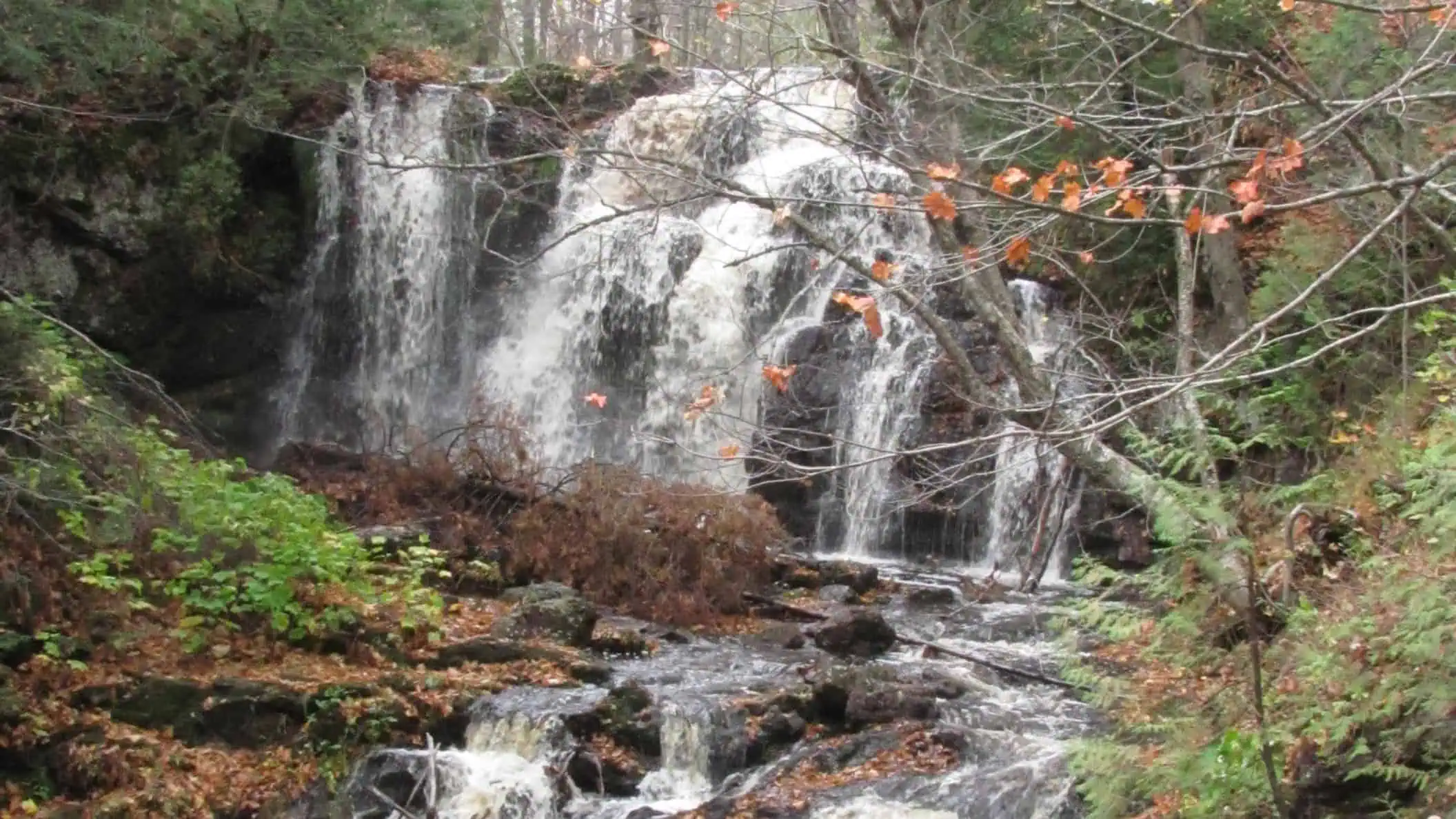
The top 10 acres, with the uppermost falls, the historic dam and the pond, now belong to the Keweenaw Land Trust. The State of Michigan owns most of the land the trails cross.

A Fire Hose Made of Creek
The land trust’s brochure spells out the dam’s job: Calumet & Hecla built it “to retain water for fire fighting in their mills along Torch Lake.” Visit Keweenaw describes the emergency procedure. In the event of a fire, “they’d throw open a valve and unleash the reservoir’s waters on their mill below.”
The same guide notes that companies like Calumet & Hecla “traded one risk for another.” A flood on purpose beats a mill burning to the ground, apparently.
Then the top of the falls went up for sale. In the final days of 2012, the uppermost falls were put up for sale by the local Torch Lake Area Fire Protection Authority. Locals rallied and raised well over $50,000 in 60 days, and the land trust took ownership in the fall of 2013.
The Dam Sits Above the Falls
Pond first, then dam, then the upper falls. Keweenaw Land Trust director B. Lauer laid out the order for The Keweenaw Report in 2025: “there’s a pond at the top that comes down the dam, which then leads down to the Upper Falls.” GoWaterfalling has the plumbing flipped, writing that “downstream of the upper falls is a dam and artificial lake.” Copper Country’s guide sides with the land trust and says the upper falls “flows off the dam.”
The old dam has had a checkup. A Michigan Tech senior design project led by Professor Stan Vitton studied it in the fall of 2013 and found it poses “little to no risk of catastrophic failure, even in our children’s lifetimes.”

Three Levels and One Big Drop
Lauer counts three levels of falls, and the largest is a 50-foot drop. At the middle falls, Visit Keweenaw says, the creek “drops straight off a sandstone ledge into a pool below,” and it rates the spot one of the most scenic waterfalls in the entire U.P. The lower falls crash so deep they are barely visible from the top, and the same guide says to be extremely careful near that cliff.
The rock tells a longer story. Michigan Tech’s Keweenaw Geoheritage site says the falls all sit downstream from the Keweenaw Fault, with Jacobsville Sandstone on show along the creek. The land trust says over a mile of ice helped carve the gorge during the last ice age 15,000 years ago, and that more than 1.1 billion years ago the area was covered in lava flows.
When to Go
Dover Creek is small. Michigan Tech describes it as “nearly dry in summer,” and GoWaterfalling says the falls are very impressive “in the spring time, or after some good rains.”
Lauer likes fall for “looking out at those broad vistas.” Winter is the favorite, when the creek turns into a gentle meander and “you get to see the coolest ice formations that form along the creek.”
Sources: Keweenaw Land Trust; The Keweenaw Report; Visit Keweenaw; Michigan Technological University (Keweenaw Geoheritage); Copper Country (coppercountry.com); GoWaterfalling; Waterfalls of the Keweenaw; Wikipedia.
Go See It
Hungarian Falls, Tamarack City / Hubbell
- Hours
- Open year-round
- Cost
- Free
- Season
- Year-round; best in spring or after good rains; winter: steepest stretches of Golf Course Road unplowed
- Drive
- From Marquette: 2 hr 6 min (109 mi) via US-41 N
From the Bridge: 4 hr 48 min (272 mi) via M-28 W and US-41 N - Winter
- park at the bottom of the hill and snowshoe up, or come from the north end near Calumet.
More worth reading


Sources, credits, and reporting details
Sources & accountability
How this story was reported
Editorial methodAggregation
Last verifiedSep. 28, 2026
Corrections statusNo material correction note is recorded on this article.
AI assistanceResearched and drafted with AI tools. Reviewed and approved by editor Keegan O’Brien.
Verification note: Sources read and checked Sept. 28, 2026.
Primary sources
-
Hungarian Falls (Keweenaw Geoheritage) — Michigan Technological University
Accessed Sep. 28, 2026.
Supports: Dover Creek; gorge toward Tamarack City
"Hungarian Falls is found on Dover Creek, a small stream which is nearly dry in summer, but which follows an impressive gorge to the ESE toward Tamarack City."
-
Hungarian Falls (Keweenaw Geoheritage) — Michigan Technological University
Accessed Sep. 28, 2026.
Supports: Gorge about 200 feet deep in places
"The gorge under Dover Creek is about 200 feet deep and 200 feet wide in places and extends steep walls about 0.5 miles toward Tamarack City below the falls."
-
Hungarian Falls Nature Area (brochure PDF) — Keweenaw Land Trust
Accessed Sep. 28, 2026.
Supports: Dam built early 1900s by Calumet & Hecla to hold water for firefighting in its Torch Lake mills
"The dam was built in the early 1900s by the Calumet & Hecla Mining Company to retain water for fire fighting in their mills along Torch Lake."
-
Hungarian Falls Nature Area — Keweenaw Land Trust
Accessed Sep. 28, 2026.
Supports: KLT owns upper 10 acres; State of Michigan owns most of trail area
"The State of Michigan owns most of the area the trails transverse and KLT owns the upper 10 acres"
-
Hungarian Falls Nature Area — Keweenaw Land Trust
Accessed Sep. 28, 2026.
Supports: 10 acres contain uppermost falls, historic dam and pond; ownership fall 2013
"KLT finally assumed responsibility for the 10 acres containing the uppermost falls, historic dam, and pond"
-
Hungarian Falls Nature Area — Keweenaw Land Trust
Accessed Sep. 28, 2026.
Supports: Ownership secured fall 2013
"After completing the legal work to secure ownership, KLT finally assumed responsibility for the 10 acres…in the fall of 2013"
-
Hungarian Falls Nature Area — Keweenaw Land Trust
Accessed Sep. 28, 2026.
Supports: Final days of 2012, put up for sale by Torch Lake Area Fire Protection Authority
"In the final days of 2012, KLT was alerted that the uppermost falls in the gorge were put up for sale by the local Torch Lake Area Fire Protection Authority"
-
Hungarian Falls Nature Area — Keweenaw Land Trust
Accessed Sep. 28, 2026.
Supports: Well over $50,000 in 60 days
"in just 60 days, we raised well over $50,000 to protect the uppermost Hungarian Falls"
-
Hungarian Falls Nature Area — Keweenaw Land Trust
Accessed Sep. 28, 2026.
Supports: Michigan Tech senior design project, Prof. Stan Vitton, fall 2013
"A senior design project led by Professor Stan Vitton with students from Michigan Tech completed a study of the Hungarian Dam and stream dynamics in the fall of 2013"
-
Hungarian Falls Nature Area — Keweenaw Land Trust
Accessed Sep. 28, 2026.
Supports: Dam poses little to no risk of catastrophic failure
"the dam poses little to no risk of catastrophic failure, even in our children's lifetimes"
-
Hungarian Falls (Keweenaw Geoheritage) — Michigan Technological University
Accessed Sep. 28, 2026.
Supports: Falls downstream from the Keweenaw Fault
"There are several falls, all located downstream from the Keweenaw Fault."
-
Hungarian Falls (Keweenaw Geoheritage) — Michigan Technological University
Accessed Sep. 28, 2026.
Supports: Jacobsville Sandstone features observable
"Walking trail access to the river allows approach to the fault itself and many places where geologic geologic features of the Jacobsville Sandstone may be observed."
-
Hungarian Falls Nature Area (brochure PDF) — Keweenaw Land Trust
Accessed Sep. 28, 2026.
Supports: Over a mile of ice, 15,000 years ago, helped create gorge
"During the last ice age 15,000 years ago, over a mile of ice helped create the massive gorge"
-
Hungarian Falls Nature Area (brochure PDF) — Keweenaw Land Trust
Accessed Sep. 28, 2026.
Supports: Over 1.1 billion years ago, lava flows
"Going back over 1.1 billion years ago, the area was once covered not in ice, but in lava flows"
-
Hungarian Falls Nature Area (brochure PDF) — Keweenaw Land Trust
Accessed Sep. 28, 2026.
Supports: Park on shoulder near sign, walk 400 yards on woods road
"Park along the shoulder near the Hungarian Falls Nature Area sign and hike in along the rough woods road for 400 yards"
-
Hungarian Falls Nature Area — Keweenaw Land Trust
Accessed Sep. 28, 2026.
Supports: Parking along Golf Course Road in warmer months
"Ample parking is available along Golf Course Road in the warmer months"
-
Hungarian Falls Nature Area — Keweenaw Land Trust
Accessed Sep. 28, 2026.
Supports: Open year-round
"The Hungarian Falls Nature Area is open year-round to the public"
-
Hungarian Falls Nature Area (brochure PDF) — Keweenaw Land Trust
Accessed Sep. 28, 2026.
Supports: Winter: road not all plowed; park at bottom and snowshoe or drive from north end near Calumet
"In winter, not all of Golf Course Road is plowed! Park at the bottom of the hill and snowshoe up or drive from the north end near Calumet to where the plow line ends."
-
Hungarian Falls Nature Area — Keweenaw Land Trust
Accessed Sep. 28, 2026.
Supports: Trails up both sides of the gorge
"A series of trails meander their way up both sides of the gorge"
-
Hungarian Falls Nature Area (brochure PDF) — Keweenaw Land Trust
Accessed Sep. 28, 2026.
Supports: Roughly 2 miles whole gorge
"Total hiking distance up and down the entire gorge is roughly 2 miles"
-
Hungarian Falls Nature Area — Keweenaw Land Trust
Accessed Sep. 28, 2026.
Supports: No camping or fires
"Camping and fires are not permitted at Hungarian Falls"
-
Hungarian Falls Nature Area (brochure PDF) — Keweenaw Land Trust
Accessed Sep. 28, 2026.
Supports: Non-motorized trails on KLT land
"All trails on KLT land are suitable for non-motorized traffic only"
-
Hungarian Falls Nature Area — Keweenaw Land Trust
Accessed Sep. 28, 2026.
Supports: Enter water/climb cliffs at own risk
"Visitors are permitted to enter the water and climb the cliffs at their own risk"
-
Hungarian Falls Nature Area — Keweenaw Land Trust
Accessed Sep. 28, 2026.
Supports: Litter
"we could use help picking up litter and please do not burn garbage or other materials near the pond"
-
Google Maps driving directions from Marquette — Google Maps
Accessed Sep. 28, 2026.
Supports: Go See It / Drive: 2 hr 6 min, 109 miles via US-41 N
Read live in Chrome Sep 28, 2026 (Monday): "2 hr 6 min 109 miles via US-41 N" (fastest route shown; destination resolved as Lower Falls).
-
Google Maps driving directions from Mackinac Bridge — Google Maps
Accessed Sep. 28, 2026.
Supports: Go See It / Drive: 4 hr 48 min, 272 miles via M-28 W and US-41 N
Read live in Chrome Sep 28, 2026 (Monday): "4 hr 48 min 272 miles via M-28 W and US-41 N" (fastest route shown; destination resolved as Lower Falls).
Additional reporting
-
Your Ultimate Hungarian Falls Adventure Guide — Visit Keweenaw
Published Aug. 19, 2022. Accessed Sep. 28, 2026.
Supports: Open a valve to release reservoir on the mill in a fire
"in the event of a fire, they'd throw open a valve and unleash the reservoir's waters on their mill below"
-
Your Ultimate Hungarian Falls Adventure Guide — Visit Keweenaw
Published Aug. 19, 2022. Accessed Sep. 28, 2026.
Supports: Reservoir used for fire suppression
"the small reservoir at the top of the gorge was used for fire suppression purposes"
-
Your Ultimate Hungarian Falls Adventure Guide — Visit Keweenaw
Published Aug. 19, 2022. Accessed Sep. 28, 2026.
Supports: Traded one risk for another
"companies like Calumet & Hecla traded one risk for another"
-
Keweenaw Land Trust stewards Hungarian Falls Nature Area across seasons changing — The Keweenaw Report
Published Aug. 13, 2025. Accessed Sep. 28, 2026.
Supports: Order: pond, dam, Upper Falls (B. Lauer, KLT director)
"So there's a pond at the top that comes down the dam, which then leads down to the Upper Falls"
-
Keweenaw Land Trust stewards Hungarian Falls Nature Area across seasons changing — The Keweenaw Report
Published Aug. 13, 2025. Accessed Sep. 28, 2026.
Supports: Former water source for fire authority (context for correction)
"This was originally used by the Torch Lake Township Fire Authority"
-
Hungarian Falls — GoWaterfalling
Accessed Sep. 28, 2026.
Supports: CORRECTION TARGET: places dam downstream of upper falls
"Downstream of the upper falls is a dam and artificial lake."
-
Hungarian Falls — Copper Country (coppercountry.com)
Accessed Sep. 28, 2026.
Supports: Upper falls flows off the dam
"The upper falls, which flows off the dam, can be accessed through a hiking trail or a gravel road."
-
Keweenaw Land Trust stewards Hungarian Falls Nature Area across seasons changing — The Keweenaw Report
Published Aug. 13, 2025. Accessed Sep. 28, 2026.
Supports: B. Lauer is KLT Director
"KLT Director B. Lauer says the space has become a popular recreation spot, where residents and visitors can enjoy a nice hike, search for thimble berries, and view the rushing waters at any time of the year."
-
Keweenaw Land Trust stewards Hungarian Falls Nature Area across seasons changing — The Keweenaw Report
Published Aug. 13, 2025. Accessed Sep. 28, 2026.
Supports: Three levels of falls
"There are three levels of falls."
-
Keweenaw Land Trust stewards Hungarian Falls Nature Area across seasons changing — The Keweenaw Report
Published Aug. 13, 2025. Accessed Sep. 28, 2026.
Supports: Largest drop 50 feet
"The largest drop in the Hungarian Falls system consists of a 50-foot drop."
-
Hungarian Falls — GoWaterfalling
Accessed Sep. 28, 2026.
Supports: Corroborates 50 ft largest drop (heights 20, 20, 50)
"Height: 20, 20, 50"
-
Your Ultimate Hungarian Falls Adventure Guide — Visit Keweenaw
Published Aug. 19, 2022. Accessed Sep. 28, 2026.
Supports: Middle falls drops off sandstone ledge; one of most scenic in U.P.
"The middle Hungarian Falls are a sight to behold and one of the most scenic waterfalls in the entire U.P.! The river drops straight off a sandstone ledge into a pool below"
-
Your Ultimate Hungarian Falls Adventure Guide — Visit Keweenaw
Published Aug. 19, 2022. Accessed Sep. 28, 2026.
Supports: Lower falls barely visible from top; be careful
"The lower Hungarian Falls crash into the depths below and are barely visible from the top. Be extremely careful near this cliff!"
-
Keweenaw Land Trust stewards Hungarian Falls Nature Area across seasons changing — The Keweenaw Report
Published Aug. 13, 2025. Accessed Sep. 28, 2026.
Supports: Winter ice formations (Lauer)
"I love coming here in the winter because it's very, the creek is a gentle meander, and you get to see the coolest ice formations that form along the creek."
-
Keweenaw Land Trust stewards Hungarian Falls Nature Area across seasons changing — The Keweenaw Report
Published Aug. 13, 2025. Accessed Sep. 28, 2026.
Supports: Fall vistas (Lauer)
"The best parts in the fall are looking out at those broad vistas"
-
Your Ultimate Hungarian Falls Adventure Guide — Visit Keweenaw
Published Aug. 19, 2022. Accessed Sep. 28, 2026.
Supports: Directions: M-26 Tamarack City, west on 6th St, left onto Golf Course Road
"Take M-26 to Tamarack City and turn west onto 6th St. opposite the hulking remnants of the Ahmeek Stamp Mill. About a block into 6th St. make a slight left turn up the hill onto Golf Course Road."
-
Your Ultimate Hungarian Falls Adventure Guide — Visit Keweenaw
Published Aug. 19, 2022. Accessed Sep. 28, 2026.
Supports: Free
"All of these waterfalls are open to the public free of charge"
-
Hungarian Falls — GoWaterfalling
Accessed Sep. 28, 2026.
Supports: Impressive in spring or after rains
"In the spring time, or after some good rains, these waterfalls are very impressive."
-
Your Ultimate Hungarian Falls Adventure Guide — Visit Keweenaw
Published Aug. 19, 2022. Accessed Sep. 28, 2026.
Supports: Steepest stretches unplowed in winter
"in winter Golf Course Road is not plowed along the steepest stretches"
-
Your Ultimate Hungarian Falls Adventure Guide — Visit Keweenaw
Published Aug. 19, 2022. Accessed Sep. 28, 2026.
Supports: About 1.5 hours
"this entire trip can be done in about 1.5 hours"
-
Hungarian Falls — GoWaterfalling
Accessed Sep. 28, 2026.
Supports: No real trail to lower falls
"There is no real trail to the lower falls."
-
Hungarian Falls on Dover Creek — Waterfalls of the Keweenaw
Accessed Sep. 28, 2026.
Supports: GPS used in Go See It (Google Maps labels this point Lower Falls)
"Location 47.17155, -88.44711"
-
Hungarian Falls — Wikipedia
Accessed Sep. 28, 2026.
Supports: Location west of Hubbell, Houghton County (corroborates coordinates ~47.17, -88.44)
"Hungarian Falls is a series of waterfalls in the Dover Creek west of Hubbell, in Houghton County, Michigan."
Photo and media credits
-
6264273845_bc6a38b799_o.jpg (featured, media 3844) — Flickr / awyu322
Featured image record. Published Oct. 15, 2011. Accessed Sep. 28, 2026. CC BY-SA 2.0.
Supports: Image credit and licence.
Licence read off the source page Sep 28, 2026; 2112×2816 original, uploaded as 2112×1188 (cropped to landscape). Caption and alt carry the credit.
-
Calumet_and_Hecla_stamp_mill,_Lake_Linden,_Mich..jpg?utm_source=commons.wikimedia.org&utm_campaign=imageinfo&utm_content=original (media 3845) — Wikimedia Commons / Detroit Publishing Co.
Accessed Sep. 28, 2026. Public domain.
Supports: Image credit and licence.
Licence read off the source page Sep 28, 2026; 9262×7458 original, uploaded as 2400×1933 (downscale). Caption and alt carry the credit.
-
6264801404_f55de47f48_o.jpg (media 3846) — Flickr / awyu322
Published Oct. 15, 2011. Accessed Sep. 28, 2026. CC BY-SA 2.0.
Supports: Image credit and licence.
Licence read off the source page Sep 28, 2026; 2112×2816 original, uploaded as 2112×1188 (cropped to landscape). Caption and alt carry the credit.
