Baraga County owns 257.7 acres at the tip of the Abbaye Peninsula, a 12.3-mile finger of forest between Keweenaw Bay and Huron Bay, and it lets people camp on the tip. The county’s recreation plan is plain about the terms. There are no official campgrounds, no utilities and no designated watercraft access. What you get is a vault toilet, a gravel lot and a quarter-mile path to the rock.
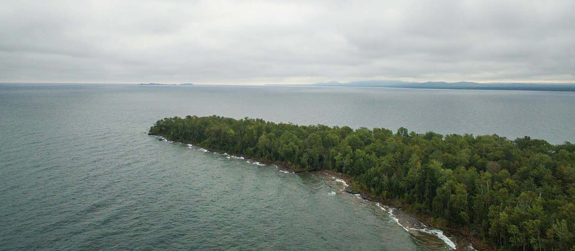
The name is said uh-BYE, and Wikipedia describes the peninsula as almost uninhabited, with no paved roads to any point on it. From the end, Visit Keweenaw says a clear day shows the full scale of the Keweenaw to the north, the rugged Huron Islands to the east and the peaks of the Huron Mountains to the southeast. One of those islands carries the Huron Island Light, first lit on October 20, 1868. It is still an active aid to navigation.

A County Park at the End of the Road
Point Abbaye itself is what Visit Keweenaw calls a tongue of forest and rock that juts out into Lake Superior. Travel listings file it as the Point Abbaye Natural Area, but the land at the tip is a Baraga County park. The county bought the Lake Superior frontage there in 1979 with a $195,000 acquisition grant, according to its 2023 to 2027 recreation plan. Outdoor Michigan’s park listing names the owner simply as Baraga County.
The first round of upgrades wrapped up in 2018 with a new accessible vault toilet, a parking area and a picnic and camping area, The Mining Gazette reported. The lone bid came in at $68,500. A $45,000 DNR Passport Grant and a $15,000 Portage Health Foundation grant covered most of it. The county paid the remaining $8,500 out of logging proceeds from county-owned land, so a slice of the bill was paid in timber.
Sandstone Ledges and Black Flies
The rock at the point is Jacobsville sandstone. Michigan Tech’s Keweenaw Geoheritage site calls it the end of a long mass of Jacobsville marked with beautiful ledges that are full of river channels. A short trail runs through the woods to the point, or you can walk out along the rocky shelves by the water. The county’s plan puts the improved path from the lot to the point at a quarter mile.
The same Michigan Tech page is honest about the downside. It says the point can be full of mosquitoes or black flies. On a day without them, it promises, you will feel the magic of a sense of place.

Logged, Farmed, Left to the Pulpwood
The peninsula stayed in the hands of the Chippewa until 1877, when the Hebard and Thurberg Lumber Company leased it from a local clan leader and his band. The old growth was cut and hauled to the sawmills at Pequaming. Efforts starting in 1914 to turn the cut-over land into farms were not successful. Today the second-growth forest is managed for pulpwood, and parcels of it sit inside the Copper Country State Forest.
Go See It
Where: Point Abbaye County Park, Arvon Township, Baraga County. GPS 46.9645, -88.1456.
Hours: None published in the county’s recreation plan or the park listings we checked.
Cost: No parking fee listed.
Season: Point Abbaye Road can be quite muddy in places in spring. For most of the warmer months it is easily passable by most vehicles with 2WD. Michigan News Source does not recommend it in winter unless you know what you are doing with a snow machine.
Drive: About 2 hours and 93 miles from Marquette, per Google Maps (read Sept. 26, 2026).
Road: From downtown L’Anse, take North Main Street, which becomes Skanee Road, about 9 miles to Townline Road. Turn left and go 4.6 miles to the end.
Camping: Allowed at the tip. The county says there are no official campgrounds and no utilities.
Facilities: Vault toilet and a crushed-gravel lot. Cell service may be spotty to non-existent.
Sources: Baraga County Recreation Plan 2023 to 2027; The Mining Gazette (Joshua Vissers, October 27, 2018); Visit Keweenaw, “A Day Trip to the Abbaye Peninsula” (May 23, 2025); Michigan Technological University’s Keweenaw Geoheritage page on Point Abbaye; Wikipedia’s articles on the Abbaye Peninsula and the Huron Island Light; Outdoor Michigan’s Point Abbaye County Park listing; Sandee’s Point Abbaye listing; Michigan News Source (Ron Rademacher, July 15, 2022).
More worth reading


Sources, credits, and reporting details
Sources & accountability
How this story was reported
Editorial methodAggregation
Last verifiedSep. 26, 2026
Corrections statusNo material correction note is recorded on this article.
AI assistanceResearched and drafted with AI tools. Reviewed and approved by editor Keegan O’Brien.
Verification note: Sources read and checked Sept. 26, 2026.
Primary sources
-
Baraga County Recreation Plan 2023-2027 — Baraga County
Accessed Sep. 26, 2026.
Supports: Point Abbaye Park is 257.7 acres at the tip
"Point Abbaye Park is 257.7 acres at the tip of Point Abbaye on the shores of Lake Superior"
-
Baraga County Recreation Plan 2023-2027 — Baraga County
Accessed Sep. 26, 2026.
"The County allows camping at the tip of the peninsula; however, there are no official campgrounds, utilities are not available and there is also not a designated watercraft access."
-
Baraga County Recreation Plan 2023-2027 — Baraga County
Accessed Sep. 26, 2026.
Supports: Vault toilet, gravel lot, quarter-mile path to the point
"the county has installed a new vault toilet. The parking lot has been improved with crushed gravel … The improved .25 mile walking path leads from the parking lot to the point"
-
A Day Trip to the Abbaye Peninsula — Visit Keweenaw
Published May. 23, 2025. Accessed Sep. 26, 2026.
Supports: View of the Keweenaw to the north
"On a clear day you can easily take in the full scale of the Keweenaw to the north."
-
A Day Trip to the Abbaye Peninsula — Visit Keweenaw
Published May. 23, 2025. Accessed Sep. 26, 2026.
Supports: Huron Islands east, Huron Mountains southeast
"To the east, the rugged Huron Islands emerge from Lake Superior, and to the southeast you can make out the peaks of the nearby Huron Mountains."
-
A Day Trip to the Abbaye Peninsula — Visit Keweenaw
Published May. 23, 2025. Accessed Sep. 26, 2026.
Supports: Point Abbaye is a tongue of forest and rock inside Point Abbaye County Park
"Point Abbaye (itself within the Point Abbaye County Park) is a tongue of forest and rock that juts out into Lake Superior."
-
Baraga County Recreation Plan 2023-2027 — Baraga County
Accessed Sep. 26, 2026.
Supports: 1979 acquisition, $195,000 grant, Lake Superior frontage
"TF61 – Point Abbaye Acquisition ($195,000), 1979 (Closed) Acquisition of 259 acres of Lake Superior frontage at the end of the Keweenaw Bay."
-
First phase of improvements done for Point Abbaye park — The Mining Gazette
Published Oct. 27, 2018. Accessed Sep. 26, 2026.
Supports: First phase: accessible vault toilet, parking, picnic and camping area
"The first phase of the Point Abbaye park improvements has been completed successfully with a new accessible vault toilet, parking area, picnic and camping area."
-
First phase of improvements done for Point Abbaye park — The Mining Gazette
Published Oct. 27, 2018. Accessed Sep. 26, 2026.
Supports: Lone bid $68,500
"The work was completed by MD Contracting, who submitted the lone bid for $68,500 that was approved in August."
-
First phase of improvements done for Point Abbaye park — The Mining Gazette
Published Oct. 27, 2018. Accessed Sep. 26, 2026.
Supports: $45,000 DNR Passport Grant and $15,000 Portage Health Foundation grant
"Funding came from a $45,000 Michigan Department of Natural Resources Passport Grant and a $15,000 Portage Health Foundation grant through the Keweenaw Community Foundation."
-
First phase of improvements done for Point Abbaye park — The Mining Gazette
Published Oct. 27, 2018. Accessed Sep. 26, 2026.
Supports: $8,500 from logging proceeds on county land
"The remaining $8,500 is paid through logging proceeds from county-owned land."
-
Pt Abbaye — Michigan Technological University, Keweenaw Geoheritage
Accessed Sep. 26, 2026.
Supports: Jacobsville ledges full of river channels
"It is the end of a long mass of Jacobsville marked with beautiful ledges that are full of river channels."
-
A Day Trip to the Abbaye Peninsula — Visit Keweenaw
Published May. 23, 2025. Accessed Sep. 26, 2026.
Supports: Short trail through woods or walk the rock shelves
"A short hiking trail meanders through the woods, or you can just hop onto the rocky shelves along the water."
-
Pt Abbaye — Michigan Technological University, Keweenaw Geoheritage
Accessed Sep. 26, 2026.
Supports: Mosquitoes, black flies, sense of place
"It can be full of mosquitoes or black flies, but on a day without them you will feel magic of 'sense of place'."
-
Point Abbaye County Park — Outdoor Michigan
Accessed Sep. 26, 2026.
Supports: Go See It: Where, GPS
"Lat, Lon: 46.9645, -88.1456"
-
Baraga County Recreation Plan 2023-2027 — Baraga County
Accessed Sep. 26, 2026.
"Point Abbaye Park is 257.7 acres at the tip of Point Abbaye on the shores of Lake Superior (see Map 2)."
-
A Day Trip to the Abbaye Peninsula — Visit Keweenaw
Published May. 23, 2025. Accessed Sep. 26, 2026.
Supports: Go See It: Season, spring mud
"Note that in the spring Point Abbaye Road can be quite muddy in places."
-
A Day Trip to the Abbaye Peninsula — Visit Keweenaw
Published May. 23, 2025. Accessed Sep. 26, 2026.
Supports: Go See It: Season, 2WD in warm months
"For most of the warmer months the road is easily passable by most vehicles with 2WD."
-
A Day Trip to the Abbaye Peninsula — Visit Keweenaw
Published May. 23, 2025. Accessed Sep. 26, 2026.
Supports: Go See It: Road, L'Anse to Skanee Road
"Drive south on US-41 and make your way to downtown L'Anse. Hang a right on North Main Street/Skanee Road and continue up the hill out of town."
-
A Day Trip to the Abbaye Peninsula — Visit Keweenaw
Published May. 23, 2025. Accessed Sep. 26, 2026.
Supports: Go See It: Road, 9 miles to Townline, left 4.6 miles
"Follow this for about 9 miles until you come to Townline Road. Turn left here and go 4.6 miles."
-
Baraga County Recreation Plan 2023-2027 — Baraga County
Accessed Sep. 26, 2026.
Supports: Go See It: Camping
"The County allows camping at the tip of the peninsula; however, there are no official campgrounds, utilities are not available"
-
Baraga County Recreation Plan 2023-2027 — Baraga County
Accessed Sep. 26, 2026.
Supports: Go See It: Facilities, vault toilet and crushed-gravel lot
"the county has installed a new vault toilet. The parking lot has been improved with crushed gravel"
-
A Day Trip to the Abbaye Peninsula — Visit Keweenaw
Published May. 23, 2025. Accessed Sep. 26, 2026.
Supports: Go See It: Cell service
"Cell service may be spotty to non-existent out on the Abbaye Peninsula."
-
Google Maps driving directions from Marquette — Google Maps
Accessed Sep. 26, 2026.
Read live in Chrome Sep 26, 2026 (Saturday), fastest route shown.
Additional reporting
-
Abbaye Peninsula — Wikipedia
Accessed Sep. 26, 2026.
Supports: Peninsula is 12.3 miles long, in Baraga County
"The Abbaye Peninsula (/əˈbaɪ/ uh-BYE) is a 12.3-mile-long (19.8 km) peninsula located within Baraga County"
-
Abbaye Peninsula — Wikipedia
Accessed Sep. 26, 2026.
Supports: Between Keweenaw Bay and Huron Bay
"It is bounded by Keweenaw Bay on the west and Huron Bay on the east."
-
Abbaye Peninsula — Wikipedia
Accessed Sep. 26, 2026.
Supports: Pronounced uh-BYE
"The Abbaye Peninsula (/əˈbaɪ/ uh-BYE)"
-
Abbaye Peninsula — Wikipedia
Accessed Sep. 26, 2026.
Supports: Almost uninhabited, no paved roads
"The thickly wooded peninsula is almost uninhabited, with no paved roads offering access to any point within the rocky promontory."
-
Abbaye Peninsula — Wikipedia
Accessed Sep. 26, 2026.
Supports: Huron Island Light sits beyond the end of the peninsula
"The Huron Island Light flashes a warning to mariners from a rocky freshwater archipelago located beyond the end of the peninsula."
-
Huron Island Light — Wikipedia
Accessed Sep. 26, 2026.
Supports: Huron Island Light first lit October 20, 1868
"The lighthouse was constructed in 1868, along with a privy, oil house, boat dock, and tramway, and was first lit on October 20 of that year."
-
Huron Island Light — Wikipedia
Accessed Sep. 26, 2026.
Supports: Still an active aid to navigation
"The light is still an active aid to navigation."
-
Point Abbaye Natural Area — Sandee
Accessed Sep. 26, 2026.
Supports: Travel listings call it Point Abbaye Natural Area (the correction)
"Point Abbaye Natural Area is nestled on the shores of Lake Superior in Powell, Michigan"
-
Point Abbaye County Park — Outdoor Michigan
Accessed Sep. 26, 2026.
Supports: Owner is Baraga County; Arvon Township
"Owner: Baraga County … Township: Arvon Township"
-
Abbaye Peninsula — Wikipedia
Accessed Sep. 26, 2026.
Supports: Chippewa until 1877; Hebard and Thurberg lease
"The peninsula remained undisturbed in the hands of the Chippewa until 1877, when the Hebard and Thurberg Lumber Company leased the peninsula from a local clan leader and his band."
-
Abbaye Peninsula — Wikipedia
Accessed Sep. 26, 2026.
Supports: Old growth went to Pequaming sawmills
"Timbering operations rapidly commenced, with the old growth forests of the peninsula axed down and carried to the sawmills at Pequaming."
-
Abbaye Peninsula — Wikipedia
Accessed Sep. 26, 2026.
Supports: Farming efforts from 1914 not successful
"Efforts, starting in 1914, to turn the cut-over real estate into arable farmland were not successful."
-
Abbaye Peninsula — Wikipedia
Accessed Sep. 26, 2026.
Supports: Second growth managed for pulpwood
"Today, the second-growth forests of the Abbaye Peninsula are managed for the production of pulpwood."
-
Abbaye Peninsula — Wikipedia
Accessed Sep. 26, 2026.
Supports: Parcels in Copper Country State Forest
"Parcels of land within the peninsula are located within the Copper Country State Forest."
-
Point Abbaye Natural Area — Sandee
Accessed Sep. 26, 2026.
Supports: Go See It: Cost, no parking fee
"Once at the site, parking is available in a small, unpaved area. There are no parking fees."
-
Point Abbaye: Remote Spot Promises Beautiful Views — Michigan News Source
Published Jul. 15, 2022. Accessed Sep. 26, 2026.
Supports: Go See It: Season, winter
"This is not a trip recommended for winter, unless you know what you are doing with a snow machine."
Photo and media credits
-
Abbaye Peninsula.jpg (featured, media 2995) — Wikimedia Commons / RomanKahler
Featured image record. Published Sep. 29, 2016. Accessed Sep. 26, 2026. CC BY-SA 4.0.
Supports: Image credit and licence.
Commons API Sep 26: 3911×1707, CC BY-SA 4.0; description "Point Abbaye, at the tip of the Abbaye Peninsula, with the Huron Mountains in the background".
-
Lake Superior Wetland in the Abbaye Peninsula (media 2996) — Wikimedia Commons / USFWS (Jim Hodgson)
Accessed Sep. 26, 2026. Public domain.
Supports: Image credit and licence.
Commons API Sep 26: 4000×3000, public domain, "Photo by Jim Hodgson/USFWS".
-
Huron National Wildlife Refuge (7455778394) (media 2997) — Wikimedia Commons / Seney Natural History Association (Jeremy Maslowski)
Published Jun. 5, 2012. Accessed Sep. 26, 2026. CC BY-SA 2.0.
Supports: Image credit and licence.
Commons API Sep 26: 3504×2336, CC BY-SA 2.0, "Photo credit: Jeremy Maslowski".

.jpg)
.jpg)