There is a photograph the National Park Service keeps of Miners Castle taken the day after April 13, 2006. It is a before-and-after, the two frames side by side, and the difference between them is the single most famous rock formation in the Upper Peninsula losing a piece of itself overnight.
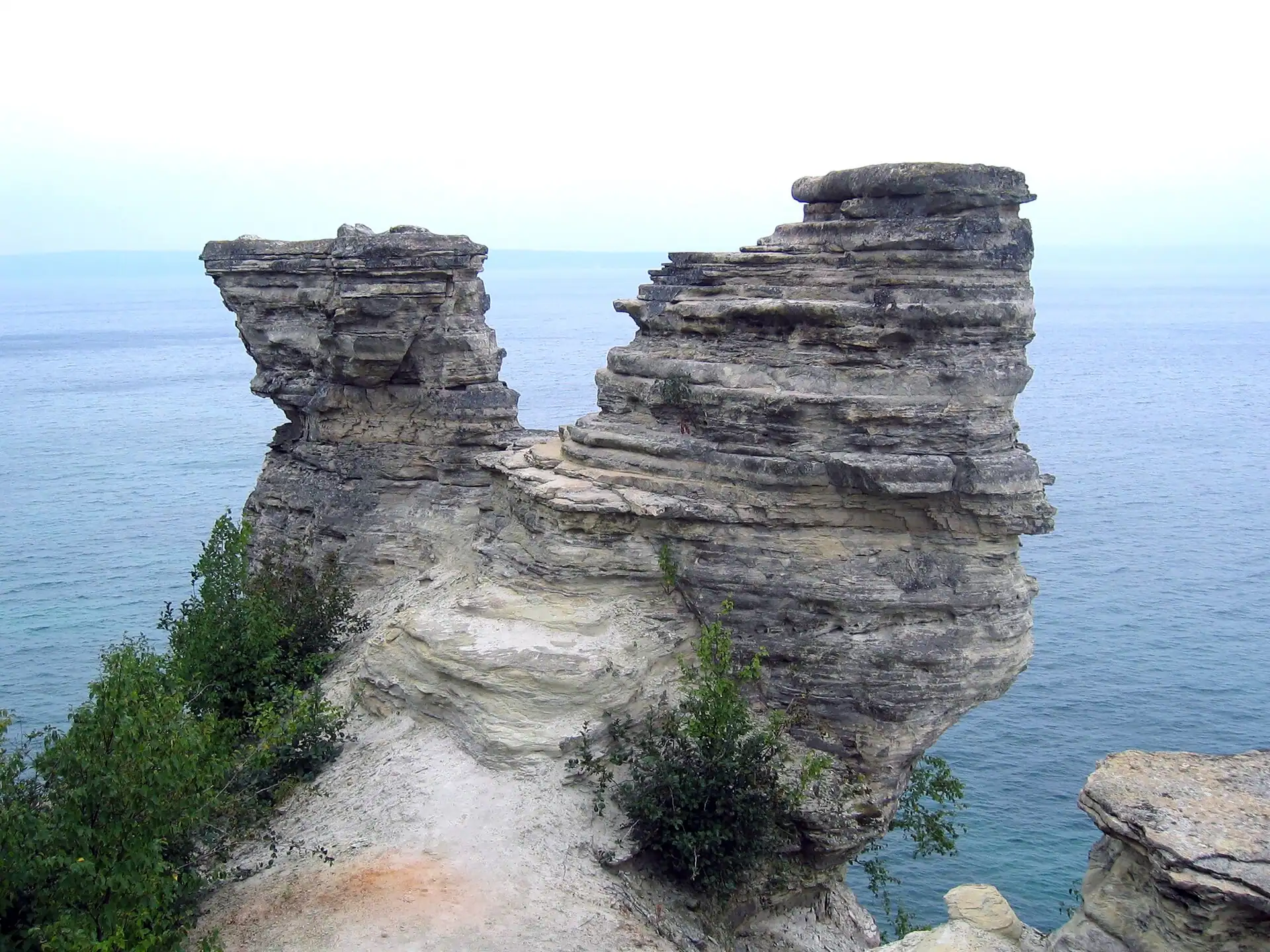
Miners Castle is the signature landmark of Pictured Rocks National Lakeshore, a knob of pale sandstone jutting into Lake Superior east of Munising, and the only stretch of those legendary cliffs you can reach by car. For generations it had two turrets, which is what earned it the castle name. On the morning of April 13, 2006, it lost one of them.
Reported by cell phone
The collapse of the northeast turret was not caught by a scientist or a webcam. It was phoned in. Fishermen out on the water that morning watched a chunk of one of Michigan’s best-known landmarks let go and slide into Lake Superior, and called it in by cell phone, according to the park’s chief ranger at the time, Larry Hach.
Most of the rock fell north, into the lake. There were no injuries, and the lower overlook platform came through untouched. By the standards of a landmark rearranging itself without warning, the U.P. got lucky: this happened on a cold April morning, not a crowded July afternoon.
A castle made of the wrong material
Here is the thing about Miners Castle: it was never built to last, because it was not built at all. It is erosion in progress, and the material is working against it.
The formation is carved from the Miners Castle Member of the Munising Formation — and per the U.S. Geological Survey research ecologist who described it, Walter Loope, that rock is crumbly, cross-bedded sandstone poorly cemented by secondary quartz. In plain terms: it is sand that never fully agreed to become stone. Water works into the cracks, freezes, expands, and pries the rock apart, over and over, every spring and every fall. The 2006 turret did not fall because something unusual happened. It fell because the ordinary thing that is always happening finally reached it.
And it is not alone. Park officials noted at the time that the same escarpment had produced at least five major rockfalls in the previous dozen years — two separate pieces of Grand Portal Point, the eastern face of Indian Head, rock at Miners Falls, and a slab beneath the lip of Munising Falls along a trail that once ran behind the cascade. Every one of them broke away from the same weak sandstone unit. The cliffs the boat tours have been cruising past since the 1940s are, geologically speaking, coming down one piece at a time.
Older than the park, named for a failure
The name is its own small U.P. story. Miners Castle was christened by the men working for the Englishman Alexander Henry, who came prospecting for minerals here in 1771. They never found the ore they were looking for. The name Miners stuck to the rock anyway, a monument to a mining venture that did not pan out — nearly two centuries before Pictured Rocks became, in October 1966, the very first National Lakeshore in the United States.
Which means the landmark is far older than its protected status, and still changing inside it. The Park Service says outright that more rockfalls are expected. The single turret standing today is not permanent either. It is simply the piece that has not gone yet.
You can still drive right to it — five miles east of Munising on H-58, then north on Miners Castle Road, to a paved path and a pair of overlooks facing the water and Grand Island beyond. Go see it. That is not a tourism slogan; it is a geological deadline. Everyone who saw Miners Castle before April 13, 2006, saw a different rock than the one standing there now, and the people who photograph it today are, whether they know it or not, taking their own before picture.
Go See It
Miners Castle, Pictured Rocks National Lakeshore
- Hours
- Park grounds open year-round, 24 hours; Miners Castle Road itself is closed in winter and reopens in spring.
- Cost
- Pictured Rocks entrance fee required: $25 per vehicle (7-day pass), $15 per person walk-in or bike-in, $45 for a Pictured Rocks annual pass. Cards only, no cash.
- Season
- Road and overlook open roughly late spring through fall; check current status before a winter or early-spring trip.
- Drive
- From Marquette: 1 hr (53.4 mi) via M-28 E
From the Bridge: 2 hr 3 min (125 mi) via US-2 W
More worth reading


Sources, credits, and reporting details
Sources & accountability
How this story was reported
Editorial methodArchival synthesis
Last verifiedJul. 23, 2026
Corrections statusNo material correction note is recorded on this article.
AI assistanceResearched and drafted with AI tools. Reviewed and approved by editor Keegan O’Brien.
Verification note: Initial ledger, verified 2026-07-23 during publication prep. The April 13 2006 collapse, the cell-phone report, the ranger name, the Munising Formation geology, the five prior rockfalls, the 1771 naming and the 1966 park establishment were checked against the primary NPS release and NPS place page plus supporting coverage. Sole direct attribution is drawn from the NPS release. Featured image is a deliberately chosen pre-collapse 2004 photograph, CC BY-SA 4.0, credit Acroterion, resized without cropping. No AI-generated or AI-assisted media.
Primary sources
-
Miners Castle Turret Collapses — National Park Service, Pictured Rocks National Lakeshore
Featured image record. Published Apr. 14, 2006. Accessed Jul. 23, 2026. Federal public information; brief quotation with attribution.
Primary NPS release; source of the cell-phone report, the ranger name, the geology, and the five-falls detail.
-
Miners Castle (U.S. National Park Service) — National Park Service
Featured image record. Accessed Jul. 23, 2026. Federal public information; cited.
Additional reporting
-
Pictured Rocks National Lakeshore — Wikipedia
Featured image record. Accessed Jul. 23, 2026. CC BY-SA text; cited.
-
The History of Pictured Rocks in Photos — Pictured Rocks Cruises
Featured image record. Published Apr. 15, 2024. Accessed Jul. 23, 2026. Copyright Pictured Rocks Cruises; cited.
-
Miners Castle of Pictured Rocks — Pictured Rocks Kayaking
Featured image record. Published Jul. 12, 2024. Accessed Jul. 23, 2026. Copyright Pictured Rocks Kayaking; cited.
Photo and media credits
-
Miners Castle 2004 MI1.jpg — Acroterion / Wikimedia Commons
Featured image record. Published Sep. 15, 2004. Accessed Jul. 23, 2026. CC BY-SA 4.0; credit Acroterion.
Pre-collapse photograph chosen deliberately to show the formation with both turrets.
